Río Bravo night lights from space
Night Light of Río Bravo (Suchitepeque) from space (Guatemala) Src. Average luminocity for 10x10km area is 3.7879% and for 50x50km: 2.4322%.
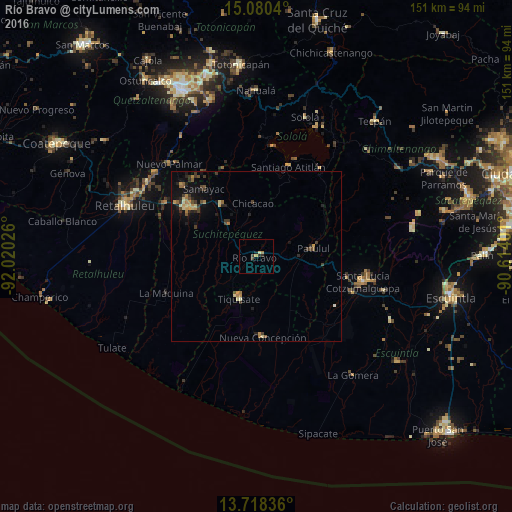
Analysis of Río Bravo night lights 2016
Square area 10x10 km:
 0%
0%90-99
0%80-89
1.3%70-79
0.43%60-69
0.87%50-59
0%40-49
0.87%30-39
1.08%20-29
1.73%10-19
0.65%0-9
93.07%Square area 50x50 km:
0%90-99
0.1%80-89
0.45%70-79
0.47%60-69
0.39%50-59
0.29%40-49
0.44%30-39
0.63%20-29
0.72%10-19
1.7%0-9
94.8%Clear (daylight) street map image can be seen on geolist.org.
Map coordinates:
15° 4' 49.4" North, 92° 1' 12.9" West
14° 24' 1.5" North, 91° 19' 1.7" West
13° 43' 6.1" North, 90° 36' 50.4" West
Some cities around Río Bravo sort by population:
• Chicacao
15.9 km =9.9 mi,  356°
356°
• Tiquisate
13.8 km =8.6 mi,  199°
199°
• Patulul
17.1 km =10.6 mi,  81°
81°
• Santa Bárbara
10.5 km =6.5 mi,  68°
68°
• Nueva Concepción
22.4 km =13.9 mi,  175°
175°
• San Antonio Suchitepéquez
18.7 km =11.6 mi,  325°
325°
• Santo Domingo Suchitepéquez
19.9 km =12.4 mi,  296°
296°
• San Bernardino
21.9 km =13.6 mi,  316°
316°
3590804 (p: 7,568)
Sources (retrieved 2019-11-25):
» Earth at Night: Flat Maps 2012, 2016