Yepocapa night lights from space
Night Light of Yepocapa (Chimaltenango) from space (Guatemala) Src. Average luminocity for 10x10km area is 1.3593% and for 50x50km: 6.4173%.
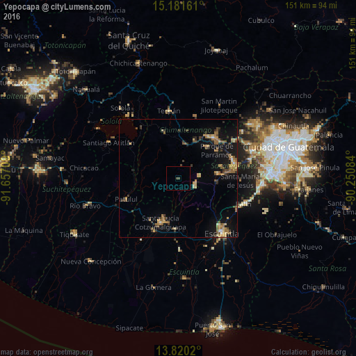
Analysis of Yepocapa night lights 2016
Square area 10x10 km:
 0%
0%90-99
0%80-89
0%70-79
0%60-69
0%50-59
0%40-49
1.73%30-39
0%20-29
0%10-19
0%0-9
98.27%Square area 50x50 km:
0.07%90-99
0.4%80-89
0.97%70-79
1.02%60-69
1.38%50-59
1.28%40-49
0.94%30-39
1.04%20-29
0.94%10-19
5.85%0-9
86.11%Clear (daylight) street map image can be seen on geolist.org.
Map coordinates:
15° 10' 53.8" North, 91° 39' 25.5" West
14° 30' 7" North, 90° 57' 14.3" West
13° 49' 12.7" North, 90° 15' 3" West
Some cities around Yepocapa sort by population:
• Santa Lucía Cotzumalguapa
20 km =12.4 mi,  201°
201°
• San Andrés Itzapa
17.9 km =11.1 mi,  41°
41°
• Alotenango
15.9 km =9.9 mi,  98°
98°
• Patzicía
14.8 km =9.2 mi,  11°
11°
• Zaragoza
17.8 km =11.1 mi,  22°
22°
• San Miguel Dueñas
16.8 km =10.4 mi,  82°
82°
• San Antonio Aguas Calientes
19.3 km =12 mi, 75°
• Acatenango
5.9 km =3.7 mi, 10°
3587636 (p: 8,961)
Sources (retrieved 2019-11-25):
» Earth at Night: Flat Maps 2012, 2016