Macouria night lights from space
Night Light of Macouria (Guyane) from space (French Guiana) Src. Average luminocity for 10x10km area is 27.6033% and for 50x50km: 5.3557%.
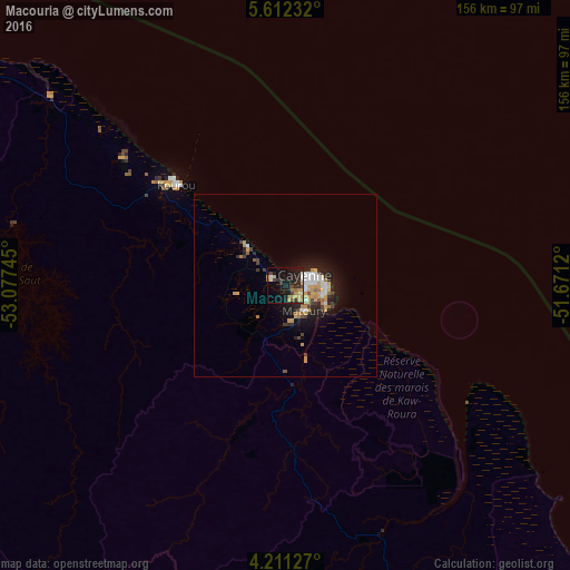
Analysis of Macouria night lights 2016
Square area 10x10 km:
 1.03%
1.03%90-99
3.72%80-89
2.07%70-79
9.71%60-69
2.48%50-59
1.86%40-49
4.13%30-39
3.31%20-29
10.95%10-19
28.1%0-9
32.64%Square area 50x50 km:
0.65%90-99
0.78%80-89
0.33%70-79
1.61%60-69
0.52%50-59
0.32%40-49
0.77%30-39
0.48%20-29
1.58%10-19
4.02%0-9
88.93%Clear (daylight) street map image can be seen on geolist.org.
Map coordinates:
5° 36' 44.4" North, 53° 4' 38.8" West
4° 54' 43.8" North, 52° 22' 27.6" West
4° 12' 40.6" North, 51° 40' 16.3" West
Some cities around Macouria sort by population:
• Cayenne
5.1 km =3.2 mi,  62°
62°
• Matoury
9 km =5.6 mi,  141°
141°
• Saint-Laurent-du-Maroni
194.6 km =120.9 mi,  289°
289°
• Kourou
40.7 km =25.3 mi,  313°
313°
• Rémire-Montjoly
11.9 km =7.4 mi,  87°
87°
• Moengo, SR
237.6 km =147.6 mi, 289°
• Mana
176.8 km =109.9 mi,  298°
298°
• Albina, SR
197.2 km =122.5 mi, 289°
3381117 (p: 8,773)
Sources (retrieved 2019-11-25):
» Earth at Night: Flat Maps 2012, 2016