Witley night lights from space
Night Light of Witley (England) from space (United Kingdom) Src. Average luminocity for 10x10km area is 3.3917% and for 50x50km: 10.5304%.
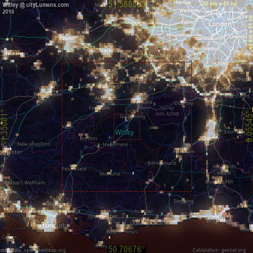
Analysis of Witley night lights 2016
Square area 10x10 km:
 0.13%
0.13%90-99
0.4%80-89
0%70-79
0%60-69
0.13%50-59
0.4%40-49
2.01%30-39
1.47%20-29
0.94%10-19
0.8%0-9
93.72%Square area 50x50 km:
0.83%90-99
1.11%80-89
0.65%70-79
0.92%60-69
1.36%50-59
2.14%40-49
3.14%30-39
3.27%20-29
3.78%10-19
8.18%0-9
74.62%Clear (daylight) street map image can be seen on geolist.org.
Map coordinates:
51° 35' 20" North, 1° 21' 2.9" West
51° 8' 59.7" North, 0° 38' 51.6" West
50° 42' 24.3" North, 0° 3' 19.6" East
Some cities around Witley sort by population:
• Guildford
10.8 km =6.7 mi,  28°
28°
• Farnham
12.8 km =8 mi,  303°
303°
• Godalming
4.6 km =2.9 mi, 29°
• Hale
13.2 km =8.2 mi,  311°
311°
• Haslemere
7.9 km =4.9 mi,  212°
212°
• Cranleigh
11.5 km =7.1 mi,  94°
94°
• Milford
2.5 km =1.6 mi,  355°
355°
• Hindhead
7.2 km =4.5 mi,  236°
236°
2633731 (p: 6,437)
Sources (retrieved 2019-11-25):
» Earth at Night: Flat Maps 2012, 2016