Hindhead night lights from space
Night Light of Hindhead (England) from space (United Kingdom) Src. Average luminocity for 10x10km area is 1.3997% and for 50x50km: 7.5105%.
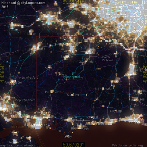
Analysis of Hindhead night lights 2016
Square area 10x10 km:
100  0%
0%
90-99 0%
80-89 0%
70-79 0%
60-69 0%
50-59 0.53%
40-49 0.53%
30-39 0.94%
20-29 1.2%
10-19 0.53%
0-9 96.26%
0%90-99
0%80-89
0%70-79
0%60-69
0%50-59
0.53%40-49
0.53%30-39
0.94%20-29
1.2%10-19
0.53%0-9
96.26%Square area 50x50 km:
100 0.6%
90-99 0.85%
80-89 0.34%
70-79 0.72%
60-69 0.99%
50-59 1.45%
40-49 1.96%
30-39 2.06%
20-29 2.34%
10-19 7.08%
0-9 81.61%
0.6%90-99
0.85%80-89
0.34%70-79
0.72%60-69
0.99%50-59
1.45%40-49
1.96%30-39
2.06%20-29
2.34%10-19
7.08%0-9
81.61%Clear (daylight) street map image can be seen on geolist.org.
Map coordinates:
51° 33' 11.2" North, 1° 26' 11.9" West
51° 6' 49.7" North, 0° 44' 0.6" West
50° 40' 13" North, 0° 1' 49.4" West
Some cities around Hindhead sort by population:
• Farnham
12.1 km =7.5 mi,  337°
337°
• Godalming
11.5 km =7.1 mi,  45°
45°
• Bordon
9 km =5.6 mi,  269°
269°
• Hale
13.4 km =8.3 mi, 343°
• Haslemere
3.2 km =2 mi,  145°
145°
• Liphook
6.4 km =4 mi,  229°
229°
• Witley
7.2 km =4.5 mi,  56°
56°
• Milford
8.7 km =5.4 mi,  41°
41°
2646863 (p: 6,187)
Sources (retrieved 2019-11-25):
» Earth at Night: Flat Maps 2012, 2016