Cranleigh night lights from space
Night Light of Cranleigh (England) from space (United Kingdom) Src. Average luminocity for 10x10km area is 1.0067% and for 50x50km: 15.6251%.
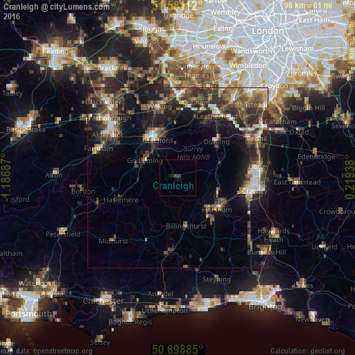
Analysis of Cranleigh night lights 2016
Square area 10x10 km:
 0%
0%90-99
0%80-89
0%70-79
0%60-69
0%50-59
0%40-49
0.8%30-39
0.27%20-29
1.34%10-19
0.8%0-9
96.79%Square area 50x50 km:
1.5%90-99
2.06%80-89
1.03%70-79
1.59%60-69
2.37%50-59
3.01%40-49
4.31%30-39
3.93%20-29
5.48%10-19
10.47%0-9
64.26%Clear (daylight) street map image can be seen on geolist.org.
Map coordinates:
51° 34' 52" North, 1° 11' 12.7" West
51° 8' 31.5" North, 0° 29' 1.5" West
50° 41' 55.9" North, 0° 13' 9.8" East
Some cities around Cranleigh sort by population:
• Guildford
12.1 km =7.5 mi,  328°
328°
• Horsham
14 km =8.7 mi,  128°
128°
• Godalming
10.4 km =6.5 mi,  297°
297°
• Dorking
14.5 km =9 mi,  46°
46°
• Billingshurst
13.4 km =8.3 mi,  170°
170°
• Witley
11.5 km =7.1 mi,  274°
274°
• Milford
12.1 km =7.5 mi,  286°
286°
• West Clandon
13.3 km =8.3 mi,  354°
354°
2652082 (p: 11,082)
Sources (retrieved 2019-11-25):
» Earth at Night: Flat Maps 2012, 2016