Haslemere night lights from space
Night Light of Haslemere (England) from space (United Kingdom) Src. Average luminocity for 10x10km area is 0.9452% and for 50x50km: 6.4278%.
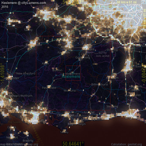
Analysis of Haslemere night lights 2016
Square area 10x10 km:
 0%
0%90-99
0%80-89
0%70-79
0%60-69
0%50-59
0%40-49
0.53%30-39
0.4%20-29
1.34%10-19
0.67%0-9
97.06%Square area 50x50 km:
0.45%90-99
0.71%80-89
0.34%70-79
0.47%60-69
0.84%50-59
1.21%40-49
1.7%30-39
1.67%20-29
1.95%10-19
6.14%0-9
84.53%Clear (daylight) street map image can be seen on geolist.org.
Map coordinates:
51° 31' 46.8" North, 1° 24' 39.5" West
51° 5' 24.5" North, 0° 42' 28.3" West
50° 38' 47.1" North, 0° 0' 17" West
Some cities around Haslemere sort by population:
• Godalming
12.5 km =7.8 mi,  31°
31°
• Bordon
11.1 km =6.9 mi,  283°
283°
• Midhurst
11.8 km =7.3 mi,  190°
190°
• Liphook
6.8 km =4.2 mi,  257°
257°
• Witley
7.9 km =4.9 mi, 32°
• Liss
13.9 km =8.6 mi,  247°
247°
• Milford
10 km =6.2 mi,  23°
23°
• Hindhead
3.2 km =2 mi,  325°
325°
2647365 (p: 13,651)
Sources (retrieved 2019-11-25):
» Earth at Night: Flat Maps 2012, 2016