West Clandon night lights from space
Night Light of West Clandon (England) from space (United Kingdom) Src. Average luminocity for 10x10km area is 15.8613% and for 50x50km: 31.1149%.
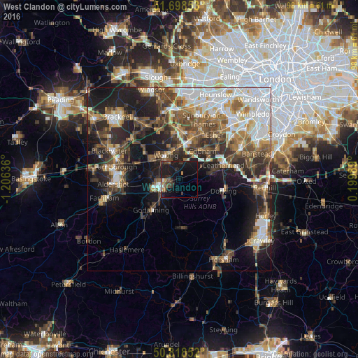
Analysis of West Clandon night lights 2016
Square area 10x10 km:
 0.7%
0.7%90-99
1.26%80-89
0%70-79
1.96%60-69
1.4%50-59
3.08%40-49
2.52%30-39
6.16%20-29
2.1%10-19
32.49%0-9
48.32%Square area 50x50 km:
6.35%90-99
5.69%80-89
2.41%70-79
3.4%60-69
4.32%50-59
5.03%40-49
6.25%30-39
5.19%20-29
7.88%10-19
13.73%0-9
39.75%Clear (daylight) street map image can be seen on geolist.org.
Map coordinates:
51° 41' 54.7" North, 1° 12' 22.9" West
51° 15' 38.3" North, 0° 30' 11.6" West
50° 49' 6.7" North, 0° 11' 59.6" East
Some cities around West Clandon sort by population:
• Woking
7.6 km =4.7 mi,  329°
329°
• Guildford
5.7 km =3.5 mi,  240°
240°
• Godalming
11.4 km =7.1 mi,  223°
223°
• Cobham
10 km =6.2 mi,  39°
39°
• Great Bookham
9.2 km =5.7 mi,  77°
77°
• Knaphill
10.2 km =6.3 mi,  310°
310°
• Send
3.5 km =2.2 mi, 332°
• East Horsley
5.2 km =3.2 mi,  73°
73°
2634469 (p: 5,422)
Sources (retrieved 2019-11-25):
» Earth at Night: Flat Maps 2012, 2016