Cobham night lights from space
Night Light of Cobham (England) from space (United Kingdom) Src. Average luminocity for 10x10km area is 42.6134% and for 50x50km: 45.5188%.
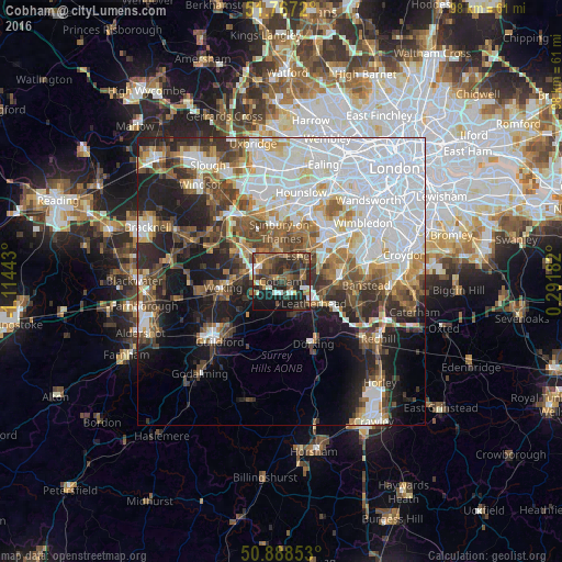
Analysis of Cobham night lights 2016
Square area 10x10 km:
 4.06%
4.06%90-99
5.18%80-89
2.1%70-79
6.16%60-69
5.6%50-59
10.64%40-49
9.94%30-39
15.27%20-29
21.71%10-19
18.63%0-9
0.7%Square area 50x50 km:
15.66%90-99
9.41%80-89
3.29%70-79
4.18%60-69
4.68%50-59
5.49%40-49
6.28%30-39
5.45%20-29
7.55%10-19
12.2%0-9
25.82%Clear (daylight) street map image can be seen on geolist.org.
Map coordinates:
51° 46' 1.9" North, 1° 6' 51.9" West
51° 19' 47.9" North, 0° 24' 40.7" West
50° 53' 18.7" North, 0° 17' 30.6" East
Some cities around Cobham sort by population:
• Esher
5.4 km =3.4 mi,  34°
34°
• Leatherhead
6.5 km =4 mi,  124°
124°
• Walton-on-Thames
6.3 km =3.9 mi,  358°
358°
• Weybridge
5.7 km =3.5 mi,  324°
324°
• Addlestone
7.3 km =4.5 mi,  308°
308°
• Great Bookham
6.2 km =3.9 mi,  155°
155°
• East Horsley
6.4 km =4 mi,  192°
192°
• West Byfleet
6.7 km =4.2 mi,  277°
277°
2652689 (p: 16,724)
Sources (retrieved 2019-11-25):
» Earth at Night: Flat Maps 2012, 2016