Send night lights from space
Night Light of Send (England) from space (United Kingdom) Src. Average luminocity for 10x10km area is 29.2163% and for 50x50km: 33.181%.
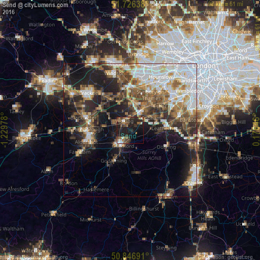
Analysis of Send night lights 2016
Square area 10x10 km:
 2.59%
2.59%90-99
2.72%80-89
1.36%70-79
3.81%60-69
2.86%50-59
7.48%40-49
5.71%30-39
9.8%20-29
9.8%10-19
33.47%0-9
20.41%Square area 50x50 km:
7.13%90-99
6.57%80-89
2.73%70-79
3.34%60-69
4.28%50-59
5.2%40-49
6.18%30-39
5.3%20-29
8.2%10-19
14.02%0-9
37.04%Clear (daylight) street map image can be seen on geolist.org.
Map coordinates:
51° 43' 35" North, 1° 13' 47.2" West
51° 17' 19.5" North, 0° 31' 36" West
50° 50' 48.9" North, 0° 10' 35.3" East
Some cities around Send sort by population:
• Woking
4 km =2.5 mi,  326°
326°
• Guildford
6.8 km =4.2 mi,  209°
209°
• Cobham
9.2 km =5.7 mi,  60°
60°
• Addlestone
9.5 km =5.9 mi,  14°
14°
• Knaphill
7.1 km =4.4 mi,  299°
299°
• East Horsley
6.8 km =4.2 mi,  104°
104°
• West Clandon
3.5 km =2.2 mi,  152°
152°
• West Byfleet
5.6 km =3.5 mi, 14°
2638207 (p: 6,597)
Sources (retrieved 2019-11-25):
» Earth at Night: Flat Maps 2012, 2016