East Horsley night lights from space
Night Light of East Horsley (England) from space (United Kingdom) Src. Average luminocity for 10x10km area is 14.6359% and for 50x50km: 36.1707%.
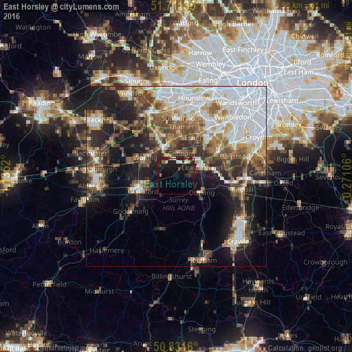
Analysis of East Horsley night lights 2016
Square area 10x10 km:
 0.98%
0.98%90-99
2.8%80-89
0.7%70-79
0.84%60-69
0.84%50-59
0.84%40-49
1.4%30-39
3.92%20-29
7.14%10-19
23.11%0-9
57.42%Square area 50x50 km:
9.88%90-99
6.97%80-89
2.71%70-79
3.64%60-69
4.36%50-59
5.12%40-49
6.26%30-39
5.12%20-29
7.3%10-19
13.34%0-9
35.3%Clear (daylight) street map image can be seen on geolist.org.
Map coordinates:
51° 42' 40.9" North, 1° 8' 6.7" West
51° 16' 24.9" North, 0° 25' 55.5" West
50° 49' 53.8" North, 0° 16' 15.8" East
Some cities around East Horsley sort by population:
• Leatherhead
7.3 km =4.5 mi,  69°
69°
• Dorking
8.2 km =5.1 mi,  123°
123°
• Cobham
6.4 km =4 mi,  12°
12°
• Ashtead
10 km =6.2 mi, 66°
• Great Bookham
4.1 km =2.5 mi,  81°
81°
• Send
6.8 km =4.2 mi,  284°
284°
• West Clandon
5.2 km =3.2 mi,  253°
253°
• West Byfleet
8.8 km =5.5 mi,  324°
324°
2650411 (p: 5,866)
Sources (retrieved 2019-11-25):
» Earth at Night: Flat Maps 2012, 2016