Great Bookham night lights from space
Night Light of Great Bookham (England) from space (United Kingdom) Src. Average luminocity for 10x10km area is 25.5434% and for 50x50km: 37.3718%.
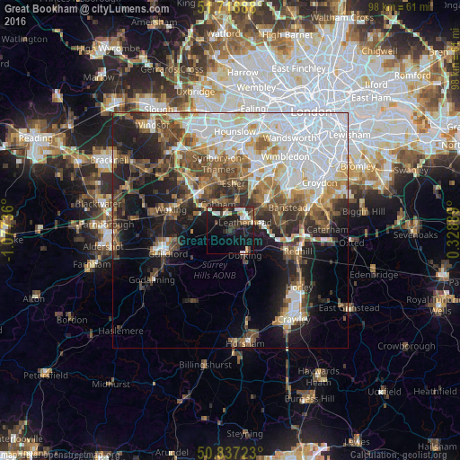
Analysis of Great Bookham night lights 2016
Square area 10x10 km:
 3.5%
3.5%90-99
7.14%80-89
0.42%70-79
1.54%60-69
2.1%50-59
1.82%40-49
3.64%30-39
5.88%20-29
8.82%10-19
28.01%0-9
37.11%Square area 50x50 km:
11.29%90-99
7.13%80-89
2.9%70-79
3.58%60-69
4.3%50-59
5.11%40-49
5.87%30-39
4.98%20-29
6.8%10-19
12.75%0-9
35.3%Clear (daylight) street map image can be seen on geolist.org.
Map coordinates:
51° 43' 0.8" North, 1° 4' 38.5" West
51° 16' 45" North, 0° 22' 27.2" West
50° 50' 14" North, 0° 19' 44" East
Some cities around Great Bookham sort by population:
• Leatherhead
3.4 km =2.1 mi,  55°
55°
• Epsom
9.2 km =5.7 mi,  51°
51°
• Dorking
5.9 km =3.7 mi,  151°
151°
• Cobham
6.2 km =3.9 mi,  335°
335°
• Ashtead
6.1 km =3.8 mi, 57°
• Tadworth
9.7 km =6 mi,  81°
81°
• East Horsley
4.1 km =2.5 mi,  261°
261°
• West Clandon
9.2 km =5.7 mi, 257°
2648154 (p: 11,000)
Sources (retrieved 2019-11-25):
» Earth at Night: Flat Maps 2012, 2016