Twyford night lights from space
Night Light of Twyford (England) from space (United Kingdom) Src. Average luminocity for 10x10km area is 26.8275% and for 50x50km: 23.7846%.
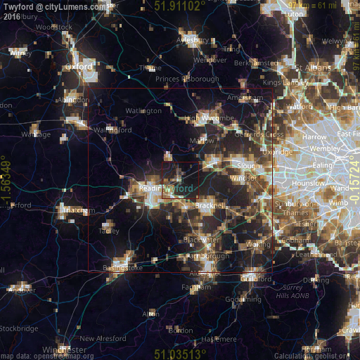
Analysis of Twyford night lights 2016
Square area 10x10 km:
 1.07%
1.07%90-99
2.81%80-89
1.2%70-79
2.67%60-69
5.61%50-59
6.55%40-49
4.14%30-39
3.34%20-29
16.31%10-19
32.09%0-9
24.2%Square area 50x50 km:
2.5%90-99
3.18%80-89
1.83%70-79
2.67%60-69
3.47%50-59
4.31%40-49
5.61%30-39
4.84%20-29
9.7%10-19
17.7%0-9
44.2%Clear (daylight) street map image can be seen on geolist.org.
Map coordinates:
51° 54' 39.7" North, 1° 33' 48.6" West
51° 28' 30.6" North, 0° 51' 37.3" West
51° 2' 6.5" North, 0° 9' 26.1" West
Some cities around Twyford sort by population:
• Reading
8 km =5 mi,  254°
254°
• Bracknell
10.2 km =6.3 mi,  131°
131°
• Maidenhead
11.1 km =6.9 mi,  61°
61°
• Wokingham
7.3 km =4.5 mi,  166°
166°
• Lower Earley
6.7 km =4.2 mi,  217°
217°
• Crowthorne
12.6 km =7.8 mi,  157°
157°
• Marlow
12 km =7.5 mi,  29°
29°
• Henley-on-Thames
7 km =4.3 mi,  337°
337°
2635294 (p: 7,533)
Sources (retrieved 2019-11-25):
» Earth at Night: Flat Maps 2012, 2016