Henley-on-Thames night lights from space
Night Light of Henley-on-Thames (England) from space (United Kingdom) Src. Average luminocity for 10x10km area is 12.7406% and for 50x50km: 20.5237%.
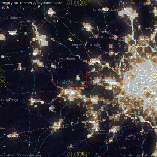
Analysis of Henley-on-Thames night lights 2016
Square area 10x10 km:
 0.8%
0.8%90-99
0.27%80-89
1.34%70-79
0.27%60-69
1.47%50-59
2.01%40-49
2.54%30-39
0.94%20-29
8.29%10-19
18.98%0-9
63.1%Square area 50x50 km:
2.21%90-99
2.85%80-89
1.51%70-79
2.15%60-69
2.77%50-59
3.57%40-49
4.6%30-39
3.89%20-29
9.23%10-19
15.5%0-9
51.73%Clear (daylight) street map image can be seen on geolist.org.
Map coordinates:
51° 58' 7" North, 1° 36' 11.3" West
51° 31' 60" North, 0° 54' 0" West
51° 5' 37.8" North, 0° 11' 48.8" West
Some cities around Henley-on-Thames sort by population:
• Reading
9.9 km =6.2 mi,  209°
209°
• Maidenhead
12.5 km =7.8 mi,  95°
95°
• Wokingham
14.3 km =8.9 mi,  161°
161°
• Lower Earley
11.9 km =7.4 mi,  186°
186°
• Marlow
9.6 km =6 mi,  65°
65°
• Twyford
7 km =4.3 mi, 157°
• Cookham
13.6 km =8.5 mi,  77°
77°
• Bourne End
13.8 km =8.6 mi, 69°
2647101 (p: 11,494)
Sources (retrieved 2019-11-25):
» Earth at Night: Flat Maps 2012, 2016