Tottington night lights from space
Night Light of Tottington (England) from space (United Kingdom) Src. Average luminocity for 10x10km area is 47.9646% and for 50x50km: 45.1338%.
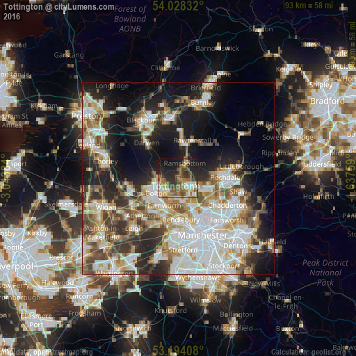
Analysis of Tottington night lights 2016
Square area 10x10 km:
 5.81%
5.81%90-99
7.2%80-89
6.06%70-79
4.42%60-69
11.62%50-59
12.75%40-49
7.7%30-39
6.69%20-29
14.9%10-19
19.82%0-9
3.03%Square area 50x50 km:
11.78%90-99
9.98%80-89
4.4%70-79
4.97%60-69
5.94%50-59
5.47%40-49
5.79%30-39
5.36%20-29
9.18%10-19
14.73%0-9
22.39%Clear (daylight) street map image can be seen on geolist.org.
Map coordinates:
54° 1' 42" North, 3° 2' 37.8" West
53° 36' 47.7" North, 2° 20' 26.6" West
53° 11' 38.7" North, 1° 38' 15.3" West
Some cities around Tottington sort by population:
• Bolton
7 km =4.3 mi,  241°
241°
• Bury
3.1 km =1.9 mi,  118°
118°
• Radcliffe
5.8 km =3.6 mi,  169°
169°
• Heywood
8.3 km =5.2 mi,  106°
106°
• Farnworth
8 km =5 mi,  209°
209°
• Whitefield
7.5 km =4.7 mi,  159°
159°
• Ramsbottom
4.2 km =2.6 mi,  22°
22°
• Little Lever
6.1 km =3.8 mi,  203°
203°
2635604 (p: 7,713)
Sources (retrieved 2019-11-25):
» Earth at Night: Flat Maps 2012, 2016