Ramsbottom night lights from space
Night Light of Ramsbottom (England) from space (United Kingdom) Src. Average luminocity for 10x10km area is 26.8561% and for 50x50km: 39.3541%.
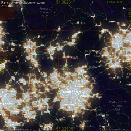
Analysis of Ramsbottom night lights 2016
Square area 10x10 km:
 0.76%
0.76%90-99
1.26%80-89
1.26%70-79
2.02%60-69
5.93%50-59
5.43%40-49
5.18%30-39
6.06%20-29
19.57%10-19
38.89%0-9
13.64%Square area 50x50 km:
9.74%90-99
8.22%80-89
3.71%70-79
4.54%60-69
5.47%50-59
4.9%40-49
5.22%30-39
4.78%20-29
8.37%10-19
14.66%0-9
30.38%Clear (daylight) street map image can be seen on geolist.org.
Map coordinates:
54° 3' 45.4" North, 3° 1' 11.9" West
53° 38' 52.4" North, 2° 19' 0.6" West
53° 13' 44.6" North, 1° 36' 49.4" West
Some cities around Ramsbottom sort by population:
• Rossendale
4.9 km =3 mi,  32°
32°
• Bury
5.4 km =3.4 mi,  168°
168°
• Radcliffe
9.6 km =6 mi,  183°
183°
• Heywood
8.9 km =5.5 mi,  133°
133°
• Rawtenstall
6.3 km =3.9 mi,  19°
19°
• Haslingden
6.2 km =3.9 mi,  355°
355°
• Tottington
4.2 km =2.6 mi,  202°
202°
• Whitworth
9.3 km =5.8 mi,  84°
84°
2639668 (p: 17,738)
Sources (retrieved 2019-11-25):
» Earth at Night: Flat Maps 2012, 2016