Stakeford night lights from space
Night Light of Stakeford (England) from space (United Kingdom) Src. Average luminocity for 10x10km area is 30.5501% and for 50x50km: 13.6873%.
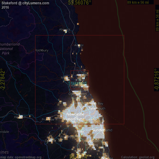
Analysis of Stakeford night lights 2016
Square area 10x10 km:
 3.01%
3.01%90-99
5.01%80-89
2.26%70-79
4.14%60-69
4.01%50-59
4.89%40-49
4.51%30-39
5.89%20-29
13.03%10-19
28.57%0-9
24.69%Square area 50x50 km:
4.56%90-99
3.28%80-89
1.31%70-79
1.07%60-69
1.01%50-59
1.1%40-49
1.02%30-39
1.85%20-29
2.88%10-19
4%0-9
77.91%Clear (daylight) street map image can be seen on geolist.org.
Map coordinates:
55° 33' 38.7" North, 2° 16' 42.3" West
55° 9' 40" North, 1° 34' 31" West
54° 45' 26.6" North, 0° 52' 19.8" West
Some cities around Stakeford sort by population:
• Blyth
5.7 km =3.5 mi,  131°
131°
• Cramlington
8.3 km =5.2 mi,  184°
184°
• Ashington
1.9 km =1.2 mi,  21°
21°
• Bedlington
3.6 km =2.2 mi,  198°
198°
• Morpeth
7.3 km =4.5 mi,  276°
276°
• Seaton Delaval
10.4 km =6.5 mi,  162°
162°
• Wideopen
13.2 km =8.2 mi,  193°
193°
• Newbiggin-by-the-Sea
4.7 km =2.9 mi,  55°
55°
11550994 (p: 9,636)
Sources (retrieved 2019-11-25):
» Earth at Night: Flat Maps 2012, 2016