Newbiggin-by-the-Sea night lights from space
Night Light of Newbiggin-by-the-Sea (England) from space (United Kingdom) Src. Average luminocity for 10x10km area is 17.3258% and for 50x50km: 11.9758%.
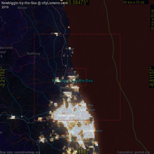
Analysis of Newbiggin-by-the-Sea night lights 2016
Square area 10x10 km:
 1.75%
1.75%90-99
1.75%80-89
0.5%70-79
1.25%60-69
2.63%50-59
3.63%40-49
3.76%30-39
3.76%20-29
8.4%10-19
18.92%0-9
53.63%Square area 50x50 km:
4.22%90-99
2.89%80-89
0.91%70-79
0.83%60-69
0.76%50-59
0.91%40-49
0.93%30-39
1.73%20-29
2.68%10-19
3.69%0-9
80.45%Clear (daylight) street map image can be seen on geolist.org.
Map coordinates:
55° 35' 5" North, 2° 13' 4.2" West
55° 11' 7.2" North, 1° 30' 52.9" West
54° 46' 54.7" North, 0° 48' 41.7" West
Some cities around Newbiggin-by-the-Sea sort by population:
• Whitley Bay
16.7 km =10.4 mi,  165°
165°
• Blyth
6.5 km =4 mi,  176°
176°
• Cramlington
11.9 km =7.4 mi,  202°
202°
• Ashington
3.3 km =2.1 mi,  253°
253°
• Bedlington
7.9 km =4.9 mi,  219°
219°
• Morpeth
11.2 km =7 mi,  260°
260°
• Stakeford
4.7 km =2.9 mi,  235°
235°
• Seaton Delaval
12.6 km =7.8 mi, 183°
2641718 (p: 6,308)
Sources (retrieved 2019-11-25):
» Earth at Night: Flat Maps 2012, 2016