Bedlington night lights from space
Night Light of Bedlington (England) from space (United Kingdom) Src. Average luminocity for 10x10km area is 34.2632% and for 50x50km: 16.3123%.
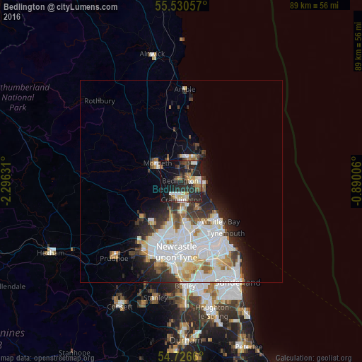
Analysis of Bedlington night lights 2016
Square area 10x10 km:
 3.51%
3.51%90-99
6.52%80-89
5.01%70-79
2.88%60-69
3.26%50-59
4.89%40-49
3.63%30-39
2.88%20-29
25.44%10-19
23.06%0-9
18.92%Square area 50x50 km:
5.41%90-99
4.04%80-89
1.54%70-79
1.34%60-69
1.19%50-59
1.33%40-49
1.11%30-39
2.14%20-29
3.41%10-19
4.59%0-9
73.91%Clear (daylight) street map image can be seen on geolist.org.
Map coordinates:
55° 31' 50.1" North, 2° 17' 46.7" West
55° 7' 50.2" North, 1° 35' 35.5" West
54° 43' 35.8" North, 0° 53' 24.2" West
Some cities around Bedlington sort by population:
• Blyth
5.4 km =3.4 mi,  94°
94°
• Cramlington
4.9 km =3 mi,  174°
174°
• Ashington
5.5 km =3.4 mi,  19°
19°
• Morpeth
7.4 km =4.6 mi,  304°
304°
• Stakeford
3.6 km =2.2 mi, 18°
• Seaton Delaval
7.8 km =4.8 mi,  146°
146°
• Wideopen
9.7 km =6 mi,  191°
191°
• Newbiggin-by-the-Sea
7.9 km =4.9 mi,  39°
39°
2656039 (p: 16,974)
Sources (retrieved 2019-11-25):
» Earth at Night: Flat Maps 2012, 2016