Wideopen night lights from space
Night Light of Wideopen (England) from space (United Kingdom) Src. Average luminocity for 10x10km area is 61.0451% and for 50x50km: 22.0059%.
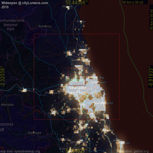
Analysis of Wideopen night lights 2016
Square area 10x10 km:
 16.92%
90-99
18.42%80-89
5.01%70-79
3.88%60-69
3.63%50-59
8.15%40-49
7.27%30-39
15.04%20-29
10.15%10-19
8.65%0-9
2.88%Square area 50x50 km:
7.2%90-99
5.1%80-89
1.84%70-79
1.74%60-69
1.88%50-59
1.91%40-49
1.78%30-39
3.48%20-29
4.95%10-19
5.99%0-9
64.12%Clear (daylight) street map image can be seen on geolist.org.
Map coordinates:
55° 26' 45.5" North, 2° 19' 32.1" West
55° 2' 42.5" North, 1° 37' 20.9" West
54° 38' 25" North, 0° 55' 9.6" West
Some cities around Wideopen sort by population:
• Newcastle upon Tyne
8 km =5 mi,  176°
176°
• Wallsend
8.2 km =5.1 mi,  136°
136°
• Cramlington
5.2 km =3.2 mi,  26°
26°
• Gosforth
5 km =3.1 mi, 175°
• Darras Hall
9.1 km =5.7 mi,  263°
263°
• Ponteland
7.8 km =4.8 mi,  274°
274°
• Seaton Delaval
6.8 km =4.2 mi,  64°
64°
• Benwell
8.6 km =5.3 mi,  200°
200°
6269321 (p: 8,976)
Sources (retrieved 2019-11-25):
» Earth at Night: Flat Maps 2012, 2016