Seaton Delaval night lights from space
Night Light of Seaton Delaval (England) from space (United Kingdom) Src. Average luminocity for 10x10km area is 49.4799% and for 50x50km: 20.9086%.
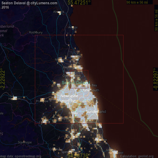
Analysis of Seaton Delaval night lights 2016
Square area 10x10 km:
 6.39%
6.39%90-99
12.78%80-89
6.02%70-79
2.76%60-69
7.02%50-59
8.9%40-49
6.14%30-39
13.28%20-29
21.05%10-19
11.4%0-9
4.26%Square area 50x50 km:
7.03%90-99
4.93%80-89
1.77%70-79
1.68%60-69
1.75%50-59
1.87%40-49
1.65%30-39
3.04%20-29
4.11%10-19
5.65%0-9
66.52%Clear (daylight) street map image can be seen on geolist.org.
Map coordinates:
55° 28' 21" North, 2° 13' 45.2" West
55° 4' 19.1" North, 1° 31' 33.9" West
54° 40' 2.5" North, 0° 49' 22.7" West
Some cities around Seaton Delaval sort by population:
• Wallsend
9 km =5.6 mi,  183°
183°
• North Shields
7.9 km =4.9 mi,  141°
141°
• Whitley Bay
6.2 km =3.9 mi,  125°
125°
• Blyth
6.2 km =3.9 mi,  10°
10°
• Cramlington
4.1 km =2.5 mi,  293°
293°
• Tynemouth
8.8 km =5.5 mi, 133°
• Bedlington
7.8 km =4.8 mi,  326°
326°
• Wideopen
6.8 km =4.2 mi,  244°
244°
2638273 (p: 9,350)
Sources (retrieved 2019-11-25):
» Earth at Night: Flat Maps 2012, 2016