Tynemouth night lights from space
Night Light of Tynemouth (England) from space (United Kingdom) Src. Average luminocity for 10x10km area is 54.9699% and for 50x50km: 22.3805%.
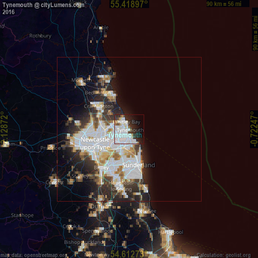
Analysis of Tynemouth night lights 2016
Square area 10x10 km:
 27.07%
90-99
14.79%80-89
2.01%70-79
1.25%60-69
2.76%50-59
1.75%40-49
1.88%30-39
5.26%20-29
12.78%10-19
12.91%0-9
17.54%Square area 50x50 km:
7.26%90-99
5.1%80-89
1.87%70-79
1.74%60-69
1.89%50-59
1.94%40-49
1.86%30-39
3.61%20-29
5.78%10-19
6.52%0-9
62.43%Clear (daylight) street map image can be seen on geolist.org.
Map coordinates:
55° 25' 8.3" North, 2° 7' 43.4" West
55° 1' 4.4" North, 1° 25' 32.1" West
54° 36' 45.8" North, 0° 43' 20.9" West
Some cities around Tynemouth sort by population:
• South Shields
2.2 km =1.4 mi,  191°
191°
• Wallsend
7.5 km =4.7 mi,  246°
246°
• North Shields
1.5 km =0.9 mi,  264°
264°
• Whitley Bay
2.8 km =1.7 mi,  330°
330°
• Jarrow
5.6 km =3.5 mi,  221°
221°
• Hebburn
7.6 km =4.7 mi,  228°
228°
• Whitburn
8 km =5 mi,  153°
153°
• East Boldon
8.2 km =5.1 mi,  181°
181°
2635269 (p: 17,436)
Sources (retrieved 2019-11-25):
» Earth at Night: Flat Maps 2012, 2016