North Shields night lights from space
Night Light of North Shields (England) from space (United Kingdom) Src. Average luminocity for 10x10km area is 71.2033% and for 50x50km: 22.6783%.

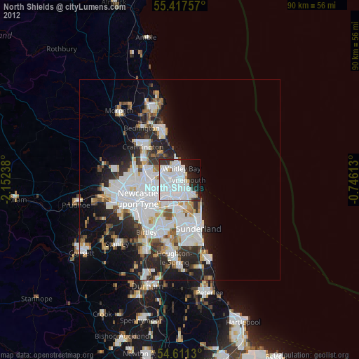
Analysis of North Shields night lights 2016
Square area 10x10 km:
 37.8%
37.8%90-99
19.62%80-89
3.11%70-79
1.32%60-69
3.59%50-59
2.03%40-49
1.91%30-39
7.3%20-29
10.77%10-19
7.78%0-9
4.78%Square area 50x50 km:
7.27%90-99
5.15%80-89
1.87%70-79
1.76%60-69
1.93%50-59
1.97%40-49
1.88%30-39
3.69%20-29
5.94%10-19
6.89%0-9
61.65%Clear (daylight) street map image can be seen on geolist.org.
Map coordinates:
55° 25' 3.3" North, 2° 9' 8.6" West
55° 0' 59.3" North, 1° 26' 57.3" West
54° 36' 40.7" North, 0° 44' 46.1" West
Some cities around North Shields sort by population:
• South Shields
2.3 km =1.4 mi,  151°
151°
• Wallsend
6.1 km =3.8 mi,  242°
242°
• Whitley Bay
2.6 km =1.6 mi,  2°
2°
• Jarrow
4.6 km =2.9 mi,  209°
209°
• Hebburn
6.4 km =4 mi,  221°
221°
• Tynemouth
1.5 km =0.9 mi,  84°
84°
• Seaton Delaval
7.9 km =4.9 mi,  321°
321°
• East Boldon
8.1 km =5 mi,  170°
170°
2641267 (p: 39,747)
Sources (retrieved 2019-11-25):
» Earth at Night: Flat Maps 2012, 2016