Ross on Wye night lights from space
Night Light of Ross on Wye (England) from space (United Kingdom) Src. Average luminocity for 10x10km area is 1.7323% and for 50x50km: 3.9647%.
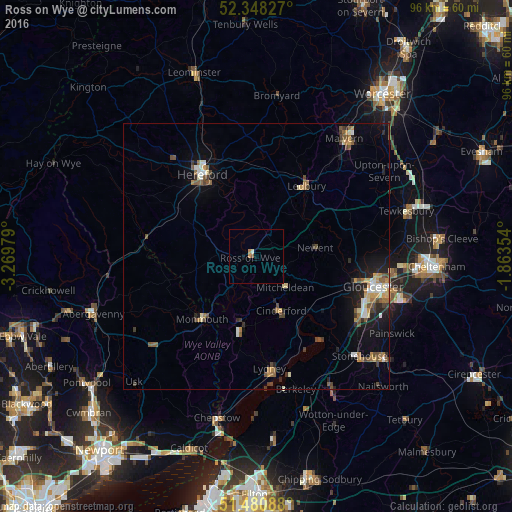
Analysis of Ross on Wye night lights 2016
Square area 10x10 km:
 0%
0%90-99
0.25%80-89
0.25%70-79
0.76%60-69
0.25%50-59
0.51%40-49
0%30-39
0%20-29
0%10-19
0.51%0-9
97.47%Square area 50x50 km:
0.31%90-99
0.52%80-89
0.43%70-79
0.51%60-69
0.58%50-59
0.86%40-49
0.66%30-39
0.45%20-29
0.85%10-19
2.39%0-9
92.43%Clear (daylight) street map image can be seen on geolist.org.
Map coordinates:
52° 20' 53.8" North, 3° 16' 11.2" West
51° 55' 0" North, 2° 34' 0" West
51° 28' 51.2" North, 1° 51' 48.7" West
Some cities around Ross on Wye sort by population:
• Gloucester
22.9 km =14.2 mi,  104°
104°
• Hereford
18.6 km =11.6 mi,  326°
326°
• Cinderford
11.3 km =7 mi,  155°
155°
• Coleford
13.9 km =8.6 mi,  193°
193°
• Monmouth
15.3 km =9.5 mi,  221°
221°
• Ledbury
16.4 km =10.2 mi,  35°
35°
• Lydney
21.4 km =13.3 mi,  172°
172°
• Stonehouse
26.9 km =16.7 mi,  133°
133°
2639110 (p: 10,582)
Sources (retrieved 2019-11-25):
» Earth at Night: Flat Maps 2012, 2016