Coleford night lights from space
Night Light of Coleford (England) from space (United Kingdom) Src. Average luminocity for 10x10km area is 3.0238% and for 50x50km: 4.2554%.
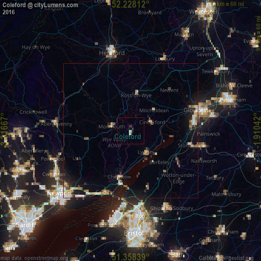
Analysis of Coleford night lights 2016
Square area 10x10 km:
 0.42%
0.42%90-99
0.7%80-89
0%70-79
0.28%60-69
0.28%50-59
0.56%40-49
0.28%30-39
0.56%20-29
0.84%10-19
0.14%0-9
95.94%Square area 50x50 km:
0.4%90-99
0.57%80-89
0.37%70-79
0.62%60-69
0.51%50-59
0.72%40-49
0.53%30-39
0.6%20-29
0.89%10-19
3.5%0-9
91.29%Clear (daylight) street map image can be seen on geolist.org.
Map coordinates:
52° 13' 41.2" North, 3° 19' 0" West
51° 47' 43.3" North, 2° 36' 48.7" West
51° 21' 30.2" North, 1° 54' 37.5" West
Some cities around Coleford sort by population:
• Chepstow
17.7 km =11 mi,  194°
194°
• Dursley
21.9 km =13.6 mi,  125°
125°
• Cinderford
8.5 km =5.3 mi,  67°
67°
• Thornbury
21.7 km =13.5 mi,  162°
162°
• Ross on Wye
13.9 km =8.6 mi,  13°
13°
• Monmouth
7.1 km =4.4 mi,  285°
285°
• Lydney
9.8 km =6.1 mi,  142°
142°
• Stonehouse
23.3 km =14.5 mi,  102°
102°
2652591 (p: 10,371)
Sources (retrieved 2019-11-25):
» Earth at Night: Flat Maps 2012, 2016