Rickmansworth night lights from space
Night Light of Rickmansworth (England) from space (United Kingdom) Src. Average luminocity for 10x10km area is 47.1429% and for 50x50km: 46.5149%.
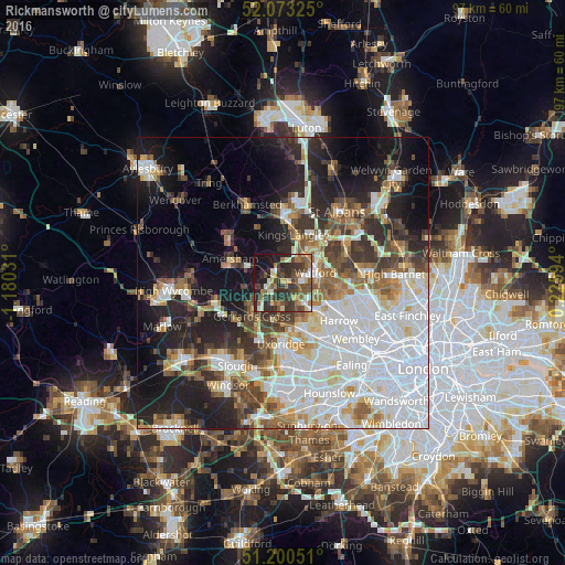
Analysis of Rickmansworth night lights 2016
Square area 10x10 km:
 4.76%
4.76%90-99
7.7%80-89
5.32%70-79
4.34%60-69
7.7%50-59
10.64%40-49
11.34%30-39
15.13%20-29
17.37%10-19
14.15%0-9
1.54%Square area 50x50 km:
14.75%90-99
10.58%80-89
4.37%70-79
3.59%60-69
4.81%50-59
5.07%40-49
5.1%30-39
5.72%20-29
8.95%10-19
14.69%0-9
22.37%Clear (daylight) street map image can be seen on geolist.org.
Map coordinates:
52° 4' 23.7" North, 1° 10' 49.1" West
51° 38' 20.3" North, 0° 28' 37.8" West
51° 12' 1.8" North, 0° 13' 33.4" East
Some cities around Rickmansworth sort by population:
• Watford
5.9 km =3.7 mi,  72°
72°
• Ruislip
8.2 km =5.1 mi,  152°
152°
• Gerrards Cross
8 km =5 mi,  222°
222°
• Chalfont Saint Peter
6.4 km =4 mi,  238°
238°
• Bushey
8.1 km =5 mi,  86°
86°
• Chorleywood
3.1 km =1.9 mi,  304°
304°
• Chalfont St Giles
6.5 km =4 mi,  262°
262°
• Harefield
4 km =2.5 mi,  188°
188°
2639381 (p: 12,043)
Sources (retrieved 2019-11-25):
» Earth at Night: Flat Maps 2012, 2016