Chalfont St Giles night lights from space
Night Light of Chalfont St Giles (England) from space (United Kingdom) Src. Average luminocity for 10x10km area is 29.7465% and for 50x50km: 40.8768%.
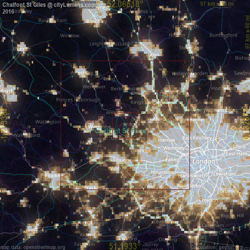
Analysis of Chalfont St Giles night lights 2016
Square area 10x10 km:
 1.68%
1.68%90-99
5.32%80-89
1.96%70-79
3.36%60-69
3.08%50-59
4.06%40-49
6.3%30-39
8.12%20-29
10.08%10-19
43.42%0-9
12.61%Square area 50x50 km:
10.04%90-99
9.45%80-89
4.06%70-79
3.81%60-69
5.17%50-59
5.4%40-49
5.06%30-39
5.46%20-29
8.87%10-19
14.23%0-9
28.45%Clear (daylight) street map image can be seen on geolist.org.
Map coordinates:
52° 3' 58.2" North, 1° 16' 24.2" West
51° 37' 54.6" North, 0° 34' 12.9" West
51° 11' 35.9" North, 0° 7' 58.3" East
Some cities around Chalfont St Giles sort by population:
• Amersham
5 km =3.1 mi,  320°
320°
• Chesham
7.9 km =4.9 mi,  344°
344°
• Gerrards Cross
5.2 km =3.2 mi,  168°
168°
• Amersham on the Hill
5.4 km =3.4 mi,  331°
331°
• Beaconsfield
5.8 km =3.6 mi,  247°
247°
• Rickmansworth
6.5 km =4 mi,  82°
82°
• Chorleywood
4.6 km =2.9 mi,  56°
56°
• Harefield
6.7 km =4.2 mi,  118°
118°
2653394 (p: 7,957)
Sources (retrieved 2019-11-25):
» Earth at Night: Flat Maps 2012, 2016