Chorleywood night lights from space
Night Light of Chorleywood (England) from space (United Kingdom) Src. Average luminocity for 10x10km area is 32.7073% and for 50x50km: 42.7177%.
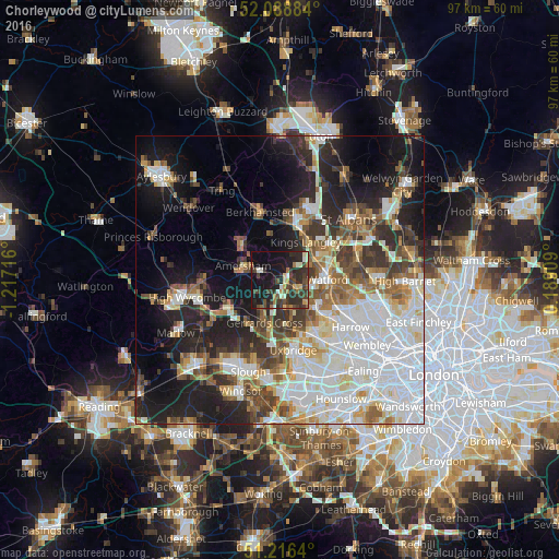
Analysis of Chorleywood night lights 2016
Square area 10x10 km:
 1.4%
1.4%90-99
5.18%80-89
3.92%70-79
2.66%60-69
4.2%50-59
1.96%40-49
9.1%30-39
11.48%20-29
18.21%10-19
30.11%0-9
11.76%Square area 50x50 km:
12.19%90-99
9.79%80-89
4.11%70-79
3.43%60-69
4.57%50-59
4.87%40-49
5.05%30-39
5.7%20-29
8.96%10-19
15.32%0-9
26%Clear (daylight) street map image can be seen on geolist.org.
Map coordinates:
52° 5' 19.8" North, 1° 13' 1.8" West
51° 39' 17" North, 0° 30' 50.5" West
51° 12' 59" North, 0° 11' 20.7" East
Some cities around Chorleywood sort by population:
• Amersham
7.2 km =4.5 mi,  280°
280°
• Chesham
7.8 km =4.8 mi,  310°
310°
• Chalfont Saint Peter
5.9 km =3.7 mi,  209°
209°
• Amersham on the Hill
6.8 km =4.2 mi,  289°
289°
• Rickmansworth
3.1 km =1.9 mi,  124°
124°
• Chalfont St Giles
4.6 km =2.9 mi,  236°
236°
• Harefield
6 km =3.7 mi,  160°
160°
• Bovingdon
7.8 km =4.8 mi,  348°
348°
2653085 (p: 11,917)
Sources (retrieved 2019-11-25):
» Earth at Night: Flat Maps 2012, 2016