Harefield night lights from space
Night Light of Harefield (England) from space (United Kingdom) Src. Average luminocity for 10x10km area is 54.8636% and for 50x50km: 50.2663%.
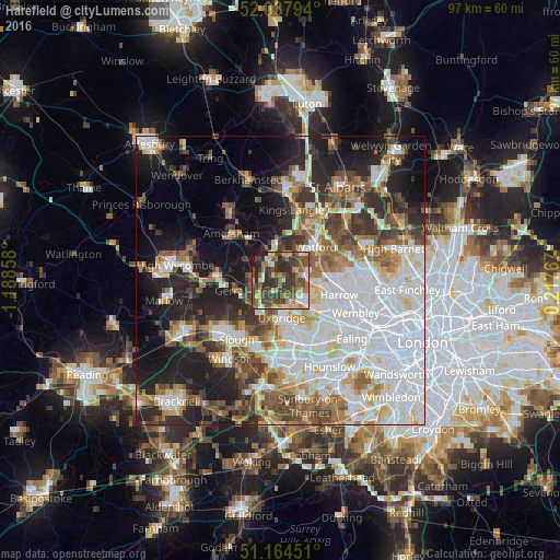
Analysis of Harefield night lights 2016
Square area 10x10 km:
 5.61%
5.61%90-99
7.89%80-89
8.02%70-79
7.22%60-69
9.36%50-59
11.9%40-49
16.18%30-39
18.98%20-29
11.1%10-19
3.74%0-9
0%Square area 50x50 km:
15.47%90-99
11.39%80-89
4.69%70-79
4.27%60-69
5.62%50-59
6.15%40-49
6.14%30-39
6.07%20-29
9.21%10-19
13.34%0-9
17.66%Clear (daylight) street map image can be seen on geolist.org.
Map coordinates:
52° 2' 16.6" North, 1° 11' 18.9" West
51° 36' 12" North, 0° 29' 7.7" West
51° 9' 52.2" North, 0° 13' 3.6" East
Some cities around Harefield sort by population:
• Ruislip
5.4 km =3.4 mi,  127°
127°
• Gerrards Cross
5.2 km =3.2 mi,  248°
248°
• Chalfont Saint Peter
4.9 km =3 mi,  277°
277°
• Pinner
7.2 km =4.5 mi,  98°
98°
• Rickmansworth
4 km =2.5 mi,  8°
8°
• Chorleywood
6 km =3.7 mi,  340°
340°
• Iver Heath
7.8 km =4.8 mi,  196°
196°
• Chalfont St Giles
6.7 km =4.2 mi,  298°
298°
2647487 (p: 6,573)
Sources (retrieved 2019-11-25):
» Earth at Night: Flat Maps 2012, 2016