Market Warsop night lights from space
Night Light of Market Warsop (England) from space (United Kingdom) Src. Average luminocity for 10x10km area is 21.9558% and for 50x50km: 24.7376%.
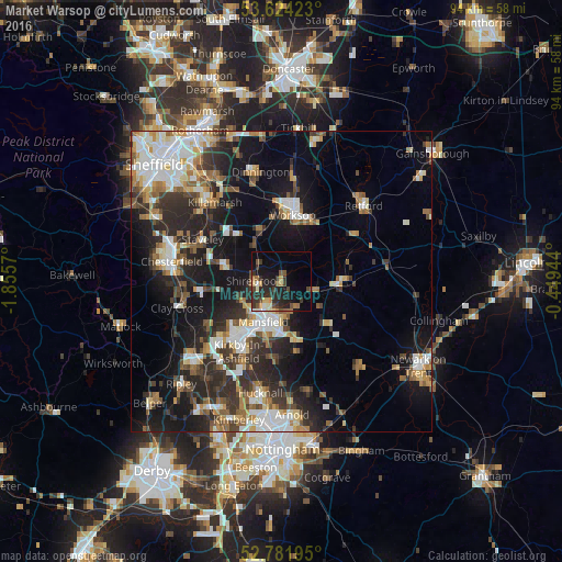
Analysis of Market Warsop night lights 2016
Square area 10x10 km:
 0.51%
0.51%90-99
2.65%80-89
2.65%70-79
2.9%60-69
2.53%50-59
3.41%40-49
4.04%30-39
6.44%20-29
10.73%10-19
15.28%0-9
48.86%Square area 50x50 km:
4.07%90-99
4.92%80-89
2.31%70-79
2.39%60-69
3.33%50-59
3.33%40-49
2.92%30-39
4.39%20-29
8.18%10-19
15.05%0-9
49.12%Clear (daylight) street map image can be seen on geolist.org.
Map coordinates:
53° 37' 27.2" North, 1° 51' 20.5" West
53° 12' 18.6" North, 1° 9' 9.3" West
52° 46' 55" North, 0° 26' 58" West
Some cities around Market Warsop sort by population:
• Mansfield
8.6 km =5.3 mi,  201°
201°
• Mansfield Woodhouse
5.2 km =3.2 mi,  211°
211°
• Bolsover
9.6 km =6 mi,  285°
285°
• Shirebrook
4.1 km =2.5 mi,  267°
267°
• Warsop
1 km =0.6 mi,  6°
6°
• Rainworth
9.9 km =6.2 mi,  166°
166°
• Creswell
7.8 km =4.8 mi,  325°
325°
• Edwinstowe
6 km =3.7 mi,  101°
101°
2643022 (p: 9,018)
Sources (retrieved 2019-11-25):
» Earth at Night: Flat Maps 2012, 2016