Creswell night lights from space
Night Light of Creswell (England) from space (United Kingdom) Src. Average luminocity for 10x10km area is 16.4407% and for 50x50km: 23.872%.
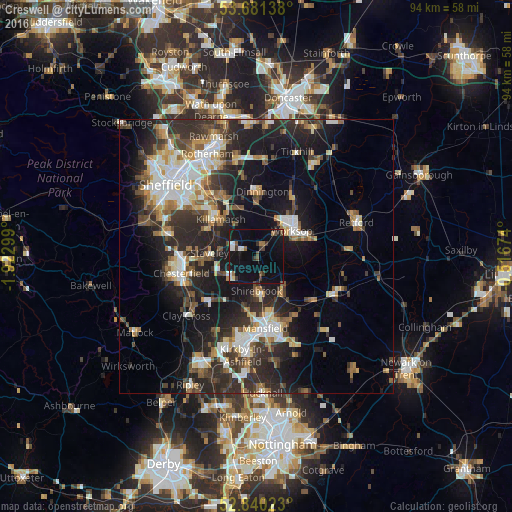
Analysis of Creswell night lights 2016
Square area 10x10 km:
 1.89%
1.89%90-99
2.02%80-89
0.63%70-79
0%60-69
2.4%50-59
1.64%40-49
2.27%30-39
4.29%20-29
1.14%10-19
24.75%0-9
58.96%Square area 50x50 km:
3.59%90-99
4.36%80-89
2.33%70-79
2.3%60-69
2.9%50-59
3.24%40-49
3.38%30-39
4.67%20-29
9.33%10-19
14.97%0-9
48.94%Clear (daylight) street map image can be seen on geolist.org.
Map coordinates:
53° 40' 53" North, 1° 55' 22.8" West
53° 15' 46.3" North, 1° 13' 11.5" West
52° 50' 24.8" North, 0° 31' 0.3" West
Some cities around Creswell sort by population:
• Worksop
7.7 km =4.8 mi,  55°
55°
• Staveley
8.7 km =5.4 mi,  272°
272°
• Bolsover
6.1 km =3.8 mi,  231°
231°
• Shirebrook
6.6 km =4.1 mi,  176°
176°
• Warsop
7.1 km =4.4 mi,  139°
139°
• Market Warsop
7.8 km =4.8 mi,  145°
145°
• Kiveton Park
9 km =5.6 mi,  345°
345°
• Clowne
3.2 km =2 mi,  293°
293°
2652007 (p: 5,417)
Sources (retrieved 2019-11-25):
» Earth at Night: Flat Maps 2012, 2016