Edwinstowe night lights from space
Night Light of Edwinstowe (England) from space (United Kingdom) Src. Average luminocity for 10x10km area is 11.7866% and for 50x50km: 21.9865%.
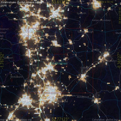
Analysis of Edwinstowe night lights 2016
Square area 10x10 km:
 0.25%
0.25%90-99
1.14%80-89
1.01%70-79
0.63%60-69
2.53%50-59
3.03%40-49
2.02%30-39
1.14%20-29
0.76%10-19
7.32%0-9
80.18%Square area 50x50 km:
3.46%90-99
4.15%80-89
1.88%70-79
2.18%60-69
2.77%50-59
3.12%40-49
2.77%30-39
4.06%20-29
7.78%10-19
14.12%0-9
53.73%Clear (daylight) street map image can be seen on geolist.org.
Map coordinates:
53° 36' 49.4" North, 1° 46' 3.1" West
53° 11' 40.3" North, 1° 3' 51.8" West
52° 46' 16.4" North, 0° 21' 40.6" West
Some cities around Edwinstowe sort by population:
• Mansfield
11.3 km =7 mi,  233°
233°
• Worksop
12.6 km =7.8 mi,  341°
341°
• Mansfield Woodhouse
9.2 km =5.7 mi,  249°
249°
• Shirebrook
10 km =6.2 mi,  275°
275°
• Boughton
5.4 km =3.4 mi,  83°
83°
• Warsop
6.2 km =3.9 mi,  290°
290°
• Market Warsop
6 km =3.7 mi, 281°
• Rainworth
9.2 km =5.7 mi,  203°
203°
2650200 (p: 5,188)
Sources (retrieved 2019-11-25):
» Earth at Night: Flat Maps 2012, 2016