Mansfield Woodhouse night lights from space
Night Light of Mansfield Woodhouse (England) from space (United Kingdom) Src. Average luminocity for 10x10km area is 54.6692% and for 50x50km: 25.2048%.
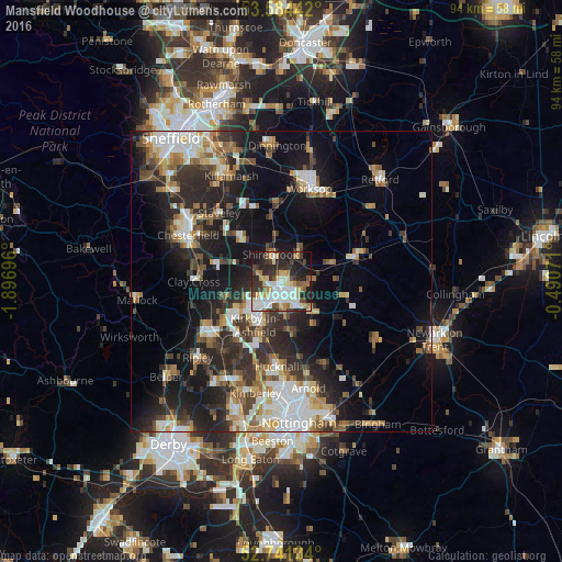
Analysis of Mansfield Woodhouse night lights 2016
Square area 10x10 km:
 10.61%
90-99
15.28%80-89
6.19%70-79
7.45%60-69
4.92%50-59
5.3%40-49
5.56%30-39
8.71%20-29
18.94%10-19
15.03%0-9
2.02%Square area 50x50 km:
4.03%90-99
4.93%80-89
2.45%70-79
2.29%60-69
3.42%50-59
3.55%40-49
3.24%30-39
4.53%20-29
9.05%10-19
15.07%0-9
47.44%Clear (daylight) street map image can be seen on geolist.org.
Map coordinates:
53° 35' 3.9" North, 1° 53' 49.1" West
53° 9' 53.8" North, 1° 11' 37.8" West
52° 44' 28.8" North, 0° 29' 26.6" West
Some cities around Mansfield Woodhouse sort by population:
• Sutton in Ashfield
6.3 km =3.9 mi,  225°
225°
• Kirkby in Ashfield
8 km =5 mi,  204°
204°
• Shirebrook
4.5 km =2.8 mi,  343°
343°
• Warsop
6.2 km =3.9 mi,  27°
27°
• Market Warsop
5.2 km =3.2 mi, 31°
• Rainworth
7.2 km =4.5 mi,  135°
135°
• Ravenshead
9 km =5.6 mi,  165°
165°
• Edwinstowe
9.2 km =5.7 mi,  69°
69°
2643096 (p: 18,330)
Sources (retrieved 2019-11-25):
» Earth at Night: Flat Maps 2012, 2016