Shirebrook night lights from space
Night Light of Shirebrook (England) from space (United Kingdom) Src. Average luminocity for 10x10km area is 29.3788% and for 50x50km: 24.1273%.
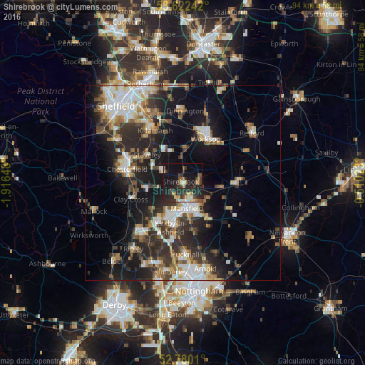
Analysis of Shirebrook night lights 2016
Square area 10x10 km:
 1.01%
1.01%90-99
3.54%80-89
4.17%70-79
4.42%60-69
3.03%50-59
3.91%40-49
3.28%30-39
8.59%20-29
18.31%10-19
28.79%0-9
20.96%Square area 50x50 km:
3.91%90-99
4.77%80-89
2.21%70-79
2.2%60-69
3.17%50-59
3.29%40-49
3.06%30-39
4.41%20-29
8.51%10-19
14.62%0-9
49.84%Clear (daylight) street map image can be seen on geolist.org.
Map coordinates:
53° 37' 20.7" North, 1° 54' 59.3" West
53° 12' 12" North, 1° 12' 48.1" West
52° 46' 48.4" North, 0° 30' 36.8" West
Some cities around Shirebrook sort by population:
• Mansfield
7.8 km =4.8 mi,  173°
173°
• Sutton in Ashfield
9.2 km =5.7 mi,  200°
200°
• Mansfield Woodhouse
4.5 km =2.8 mi,  163°
163°
• Bolsover
5.9 km =3.7 mi,  298°
298°
• Warsop
4.3 km =2.7 mi,  74°
74°
• Market Warsop
4.1 km =2.5 mi,  87°
87°
• Clowne
8.6 km =5.3 mi,  336°
336°
• Creswell
6.6 km =4.1 mi,  356°
356°
2637941 (p: 10,885)
Sources (retrieved 2019-11-25):
» Earth at Night: Flat Maps 2012, 2016