Bolsover night lights from space
Night Light of Bolsover (England) from space (United Kingdom) Src. Average luminocity for 10x10km area is 23.7348% and for 50x50km: 23.8609%.
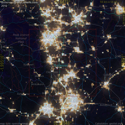
Analysis of Bolsover night lights 2016
Square area 10x10 km:
 2.15%
2.15%90-99
3.54%80-89
1.14%70-79
0.76%60-69
2.27%50-59
2.53%40-49
4.42%30-39
5.43%20-29
6.19%10-19
54.29%0-9
17.3%Square area 50x50 km:
3.7%90-99
4.63%80-89
2.29%70-79
2.3%60-69
3.09%50-59
3.32%40-49
3.2%30-39
4.43%20-29
8.37%10-19
14.59%0-9
50.06%Clear (daylight) street map image can be seen on geolist.org.
Map coordinates:
53° 38' 50.3" North, 1° 59' 42.6" West
53° 13' 42.5" North, 1° 17' 31.3" West
52° 48' 19.7" North, 0° 35' 20.1" West
Some cities around Bolsover sort by population:
• Chesterfield
8.6 km =5.3 mi,  286°
286°
• Staveley
5.7 km =3.5 mi,  317°
317°
• Mansfield Woodhouse
9.6 km =6 mi,  137°
137°
• Shirebrook
5.9 km =3.7 mi,  118°
118°
• Warsop
9.5 km =5.9 mi,  99°
99°
• Market Warsop
9.6 km =6 mi,  105°
105°
• Clowne
5.4 km =3.4 mi,  19°
19°
• Creswell
6.1 km =3.8 mi,  51°
51°
2655242 (p: 11,754)
Sources (retrieved 2019-11-25):
» Earth at Night: Flat Maps 2012, 2016