Iver night lights from space
Night Light of Iver (England) from space (United Kingdom) Src. Average luminocity for 10x10km area is 77.6043% and for 50x50km: 52.994%.
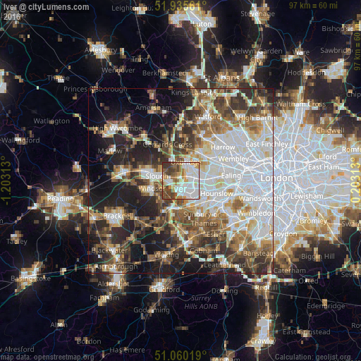
Analysis of Iver night lights 2016
Square area 10x10 km:
 24.73%
90-99
22.73%80-89
7.75%70-79
9.49%60-69
6.82%50-59
8.02%40-49
11.76%30-39
8.42%20-29
0.27%10-19
0%0-9
0%Square area 50x50 km:
14.46%90-99
11.53%80-89
4.93%70-79
5.01%60-69
6.63%50-59
7.43%40-49
7.89%30-39
7.42%20-29
10.55%10-19
14.19%0-9
9.95%Clear (daylight) street map image can be seen on geolist.org.
Map coordinates:
51° 56' 8.2" North, 1° 12' 11.3" West
51° 30' 0" North, 0° 30' 0" West
51° 3' 36.7" North, 0° 12' 11.3" East
Some cities around Iver sort by population:
• Slough
6.7 km =4.2 mi,  279°
279°
• Staines
7.7 km =4.8 mi,  183°
183°
• Hayes
5.6 km =3.5 mi,  71°
71°
• Windsor
7.2 km =4.5 mi,  255°
255°
• West Drayton
2.3 km =1.4 mi,  90°
90°
• Iver Heath
4.2 km =2.6 mi,  342°
342°
• Old Windsor
7.6 km =4.7 mi,  232°
232°
• Colnbrook
2.3 km =1.4 mi,  219°
219°
2645990 (p: 7,492)
Sources (retrieved 2019-11-25):
» Earth at Night: Flat Maps 2012, 2016