Old Windsor night lights from space
Night Light of Old Windsor (England) from space (United Kingdom) Src. Average luminocity for 10x10km area is 51.8663% and for 50x50km: 45.0047%.
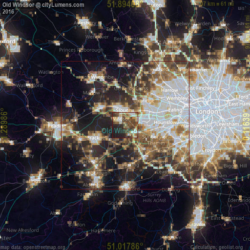
Analysis of Old Windsor night lights 2016
Square area 10x10 km:
100  5.88%
5.88%
90-99 9.36%
80-89 7.22%
70-79 7.49%
60-69 4.68%
50-59 10.96%
40-49 15.11%
30-39 11.23%
20-29 15.64%
10-19 12.43%
0-9 0%
5.88%90-99
9.36%80-89
7.22%70-79
7.49%60-69
4.68%50-59
10.96%40-49
15.11%30-39
11.23%20-29
15.64%10-19
12.43%0-9
0%Square area 50x50 km:
100 9.82%
90-99 9.54%
80-89 3.9%
70-79 4.7%
60-69 6.26%
50-59 7.01%
40-49 7.46%
30-39 6.82%
20-29 10.63%
10-19 16.95%
0-9 16.92%
9.82%90-99
9.54%80-89
3.9%70-79
4.7%60-69
6.26%50-59
7.01%40-49
7.46%30-39
6.82%20-29
10.63%10-19
16.95%0-9
16.92%Clear (daylight) street map image can be seen on geolist.org.
Map coordinates:
51° 53' 38.7" North, 1° 17' 23.5" West
51° 27' 29.1" North, 0° 35' 12.3" West
51° 1' 4.3" North, 0° 6' 59" East
Some cities around Old Windsor sort by population:
• Slough
5.7 km =3.5 mi,  354°
354°
• Staines
6.4 km =4 mi,  118°
118°
• Windsor
3 km =1.9 mi,  341°
341°
• Egham
3.8 km =2.4 mi,  141°
141°
• Ashford
9.4 km =5.8 mi,  108°
108°
• Ascot
8.1 km =5 mi,  229°
229°
• Iver
7.6 km =4.7 mi,  52°
52°
• Colnbrook
5.4 km =3.4 mi,  57°
57°
2640981 (p: 7,168)
Sources (retrieved 2019-11-25):
» Earth at Night: Flat Maps 2012, 2016