Iver Heath night lights from space
Night Light of Iver Heath (England) from space (United Kingdom) Src. Average luminocity for 10x10km area is 68.881% and for 50x50km: 51.0623%.
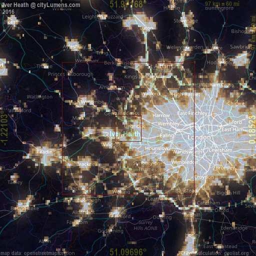
Analysis of Iver Heath night lights 2016
Square area 10x10 km:
 15.64%
90-99
15.64%80-89
9.22%70-79
8.69%60-69
9.49%50-59
11.76%40-49
13.24%30-39
12.57%20-29
3.74%10-19
0%0-9
0%Square area 50x50 km:
13.47%90-99
11.13%80-89
4.8%70-79
4.93%60-69
6.67%50-59
7.53%40-49
7.65%30-39
7.37%20-29
10.06%10-19
12.32%0-9
14.06%Clear (daylight) street map image can be seen on geolist.org.
Map coordinates:
51° 58' 18" North, 1° 13' 15.7" West
51° 32' 11.1" North, 0° 31' 4.4" West
51° 5' 49.1" North, 0° 11' 6.8" East
Some cities around Iver Heath sort by population:
• Slough
6.1 km =3.8 mi,  240°
240°
• Hayes
6.9 km =4.3 mi,  109°
109°
• Ruislip
7.7 km =4.8 mi,  57°
57°
• Gerrards Cross
6.1 km =3.8 mi,  334°
334°
• West Drayton
5.4 km =3.4 mi,  138°
138°
• Iver
4.2 km =2.6 mi,  162°
162°
• Farnham Royal
6.8 km =4.2 mi,  275°
275°
• Colnbrook
5.9 km =3.7 mi,  182°
182°
7290170 (p: 8,065)
Sources (retrieved 2019-11-25):
» Earth at Night: Flat Maps 2012, 2016