West Drayton night lights from space
Night Light of West Drayton (England) from space (United Kingdom) Src. Average luminocity for 10x10km area is 86.4465% and for 50x50km: 55.9602%.
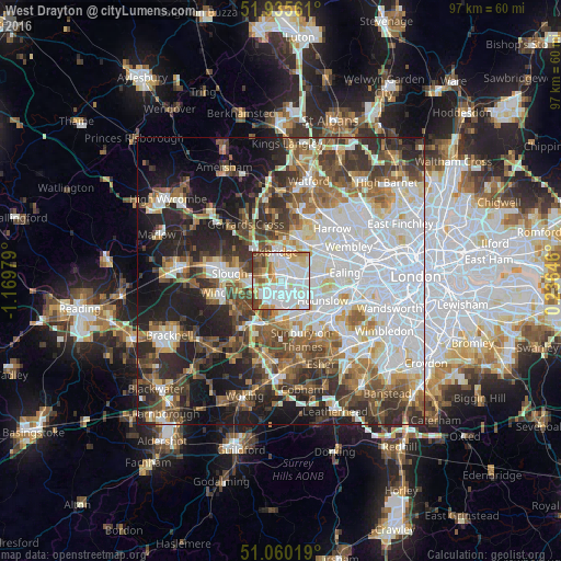
Analysis of West Drayton night lights 2016
Square area 10x10 km:
 32.89%
90-99
28.48%80-89
10.43%70-79
8.56%60-69
6.68%50-59
5.48%40-49
5.61%30-39
1.87%20-29
0%10-19
0%0-9
0%Square area 50x50 km:
17.03%90-99
11.99%80-89
5.12%70-79
4.99%60-69
6.58%50-59
7.51%40-49
7.85%30-39
7.44%20-29
10.47%10-19
13.48%0-9
7.54%Clear (daylight) street map image can be seen on geolist.org.
Map coordinates:
51° 56' 8.2" North, 1° 10' 11.2" West
51° 30' 0" North, 0° 28' 0" West
51° 3' 36.7" North, 0° 14' 11.3" East
Some cities around West Drayton sort by population:
• Southall
6.7 km =4.2 mi,  81°
81°
• Hounslow
8.1 km =5 mi,  115°
115°
• Hayes
3.5 km =2.2 mi,  59°
59°
• Ashford
7.6 km =4.7 mi,  175°
175°
• Feltham
7 km =4.3 mi,  148°
148°
• Iver Heath
5.4 km =3.4 mi,  318°
318°
• Iver
2.3 km =1.4 mi,  270°
270°
• Colnbrook
4.2 km =2.6 mi,  244°
244°
2634451 (p: 12,156)
Sources (retrieved 2019-11-25):
» Earth at Night: Flat Maps 2012, 2016