Colnbrook night lights from space
Night Light of Colnbrook (England) from space (United Kingdom) Src. Average luminocity for 10x10km area is 73.0655% and for 50x50km: 50.9968%.
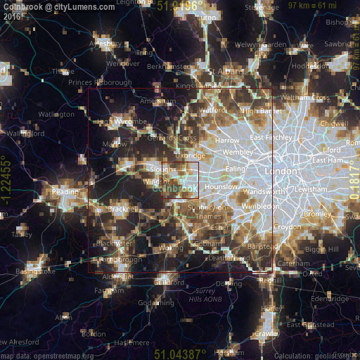
Analysis of Colnbrook night lights 2016
Square area 10x10 km:
 18.85%
90-99
18.18%80-89
8.29%70-79
9.89%60-69
10.03%50-59
10.83%40-49
14.71%30-39
8.69%20-29
0.53%10-19
0%0-9
0%Square area 50x50 km:
13.19%90-99
11.07%80-89
4.66%70-79
4.94%60-69
6.53%50-59
7.3%40-49
7.71%30-39
7.32%20-29
10.63%10-19
15.41%0-9
11.25%Clear (daylight) street map image can be seen on geolist.org.
Map coordinates:
51° 55' 10.6" North, 1° 13' 28.4" West
51° 29' 1.8" North, 0° 31' 17.1" West
51° 2' 37.9" North, 0° 10' 54.1" East
Some cities around Colnbrook sort by population:
• Slough
5.9 km =3.7 mi,  299°
299°
• Staines
6 km =3.7 mi,  169°
169°
• Windsor
5.4 km =3.4 mi,  269°
269°
• Egham
6.2 km =3.9 mi,  200°
200°
• West Drayton
4.2 km =2.6 mi,  64°
64°
• Iver Heath
5.9 km =3.7 mi,  2°
2°
• Iver
2.3 km =1.4 mi,  39°
39°
• Old Windsor
5.4 km =3.4 mi,  237°
237°
2652546 (p: 5,528)
Sources (retrieved 2019-11-25):
» Earth at Night: Flat Maps 2012, 2016