Cookham night lights from space
Night Light of Cookham (England) from space (United Kingdom) Src. Average luminocity for 10x10km area is 38.7754% and for 50x50km: 33.6115%.
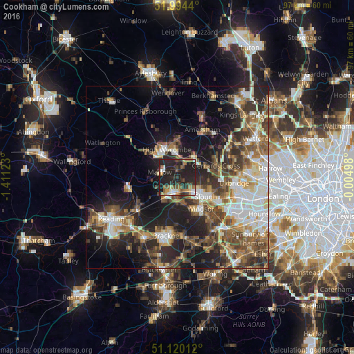
Analysis of Cookham night lights 2016
Square area 10x10 km:
 3.21%
3.21%90-99
5.88%80-89
2.94%70-79
4.01%60-69
9.09%50-59
3.88%40-49
4.41%30-39
6.42%20-29
35.43%10-19
24.73%0-9
0%Square area 50x50 km:
5.44%90-99
6.36%80-89
3.41%70-79
3.61%60-69
4.69%50-59
5.94%40-49
6.61%30-39
5.65%20-29
10.11%10-19
14.22%0-9
33.96%Clear (daylight) street map image can be seen on geolist.org.
Map coordinates:
51° 59' 39.8" North, 1° 24' 40.4" West
51° 33' 33.7" North, 0° 42' 29.2" West
51° 7' 12.4" North, 0° 0' 17.9" West
Some cities around Cookham sort by population:
• Slough
9.6 km =6 mi,  125°
125°
• High Wycombe
8.3 km =5.2 mi,  339°
339°
• Maidenhead
4.1 km =2.5 mi,  191°
191°
• Gerrards Cross
11 km =6.8 mi,  74°
74°
• Marlow
4.7 km =2.9 mi,  283°
283°
• Beaconsfield
7.2 km =4.5 mi,  35°
35°
• Farnham Royal
6.7 km =4.2 mi,  106°
106°
• Bourne End
1.9 km =1.2 mi,  349°
349°
2652423 (p: 5,422)
Sources (retrieved 2019-11-25):
» Earth at Night: Flat Maps 2012, 2016