Bourne End night lights from space
Night Light of Bourne End (England) from space (United Kingdom) Src. Average luminocity for 10x10km area is 34.7634% and for 50x50km: 32.6082%.
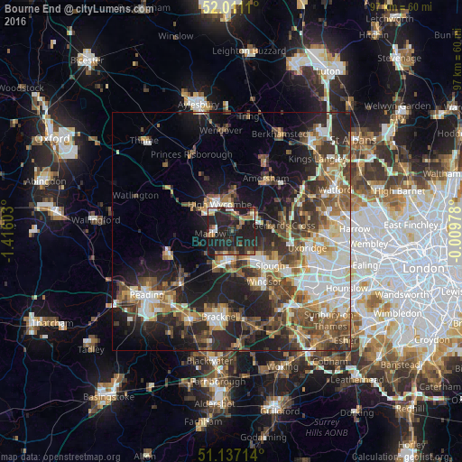
Analysis of Bourne End night lights 2016
Square area 10x10 km:
 2.81%
2.81%90-99
3.74%80-89
2.27%70-79
2.81%60-69
7.35%50-59
3.48%40-49
5.21%30-39
5.75%20-29
37.03%10-19
29.55%0-9
0%Square area 50x50 km:
5.27%90-99
6.28%80-89
3.3%70-79
3.48%60-69
4.49%50-59
5.6%40-49
6.17%30-39
5.39%20-29
10.02%10-19
14.4%0-9
35.59%Clear (daylight) street map image can be seen on geolist.org.
Map coordinates:
52° 0' 40" North, 1° 24' 57.7" West
51° 34' 34.4" North, 0° 42' 46.5" West
51° 8' 13.7" North, 0° 0' 35.2" West
Some cities around Bourne End sort by population:
• Slough
11 km =6.8 mi,  132°
132°
• High Wycombe
6.4 km =4 mi,  336°
336°
• Maidenhead
6 km =3.7 mi,  184°
184°
• Gerrards Cross
10.9 km =6.8 mi,  84°
84°
• Marlow
4.3 km =2.7 mi,  259°
259°
• Beaconsfield
6 km =3.7 mi,  48°
48°
• Farnham Royal
7.7 km =4.8 mi,  119°
119°
• Cookham
1.9 km =1.2 mi,  169°
169°
2655097 (p: 5,320)
Sources (retrieved 2019-11-25):
» Earth at Night: Flat Maps 2012, 2016