Tadworth night lights from space
Night Light of Tadworth (England) from space (United Kingdom) Src. Average luminocity for 10x10km area is 40.9594% and for 50x50km: 42.9106%.
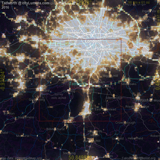
Analysis of Tadworth night lights 2016
Square area 10x10 km:
100  2.52%
2.52%
90-99 5.18%
80-89 0.84%
70-79 3.5%
60-69 7.14%
50-59 8.4%
40-49 17.93%
30-39 13.87%
20-29 23.81%
10-19 16.11%
0-9 0.7%
2.52%90-99
5.18%80-89
0.84%70-79
3.5%60-69
7.14%50-59
8.4%40-49
17.93%30-39
13.87%20-29
23.81%10-19
16.11%0-9
0.7%Square area 50x50 km:
100 15.43%
90-99 9.24%
80-89 3.81%
70-79 4%
60-69 4.61%
50-59 4.45%
40-49 5.02%
30-39 4.37%
20-29 5.33%
10-19 8.57%
0-9 35.17%
15.43%90-99
9.24%80-89
3.81%70-79
4%60-69
4.61%50-59
4.45%40-49
5.02%30-39
4.37%20-29
5.33%10-19
8.57%0-9
35.17%Clear (daylight) street map image can be seen on geolist.org.
Map coordinates:
51° 43' 45.4" North, 0° 56' 20.2" West
51° 17' 30.1" North, 0° 14' 9" West
50° 50' 59.6" North, 0° 28' 2.3" East
Some cities around Tadworth sort by population:
• Sutton
6.9 km =4.3 mi,  21°
21°
• Reigate
6.4 km =4 mi,  160°
160°
• Banstead
4 km =2.5 mi,  30°
30°
• Leatherhead
6.8 km =4.2 mi,  274°
274°
• Ewell
6.5 km =4 mi,  351°
351°
• Epsom
4.9 km =3 mi,  331°
331°
• Coulsdon
7.3 km =4.5 mi,  64°
64°
• Ashtead
4.8 km =3 mi,  293°
293°
2636331 (p: 6,999)
Sources (retrieved 2019-11-25):
» Earth at Night: Flat Maps 2012, 2016