Dorking night lights from space
Night Light of Dorking (England) from space (United Kingdom) Src. Average luminocity for 10x10km area is 8.1359% and for 50x50km: 29.7317%.
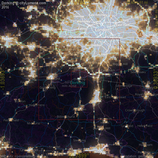
Analysis of Dorking night lights 2016
Square area 10x10 km:
 0.42%
0.42%90-99
0.7%80-89
0%70-79
1.12%60-69
0%50-59
0%40-49
1.68%30-39
1.68%20-29
0.56%10-19
20.17%0-9
73.67%Square area 50x50 km:
6.83%90-99
5.46%80-89
2.52%70-79
3.3%60-69
4.11%50-59
4.71%40-49
5.24%30-39
4.55%20-29
5.82%10-19
11.68%0-9
45.78%Clear (daylight) street map image can be seen on geolist.org.
Map coordinates:
51° 40' 13.6" North, 1° 2' 12.9" West
51° 13' 56.2" North, 0° 20' 1.7" West
50° 47' 23.6" North, 0° 22' 9.6" East
Some cities around Dorking sort by population:
• Reigate
8.9 km =5.5 mi,  86°
86°
• Redhill
11.4 km =7.1 mi, 85°
• Leatherhead
7.1 km =4.4 mi,  0°
0°
• Epsom
11.8 km =7.3 mi,  22°
22°
• Ashtead
8.8 km =5.5 mi, 15°
• Great Bookham
5.9 km =3.7 mi,  331°
331°
• Tadworth
9.5 km =5.9 mi,  45°
45°
• East Horsley
8.2 km =5.1 mi,  303°
303°
2651095 (p: 17,747)
Sources (retrieved 2019-11-25):
» Earth at Night: Flat Maps 2012, 2016