Ashtead night lights from space
Night Light of Ashtead (England) from space (United Kingdom) Src. Average luminocity for 10x10km area is 44.6162% and for 50x50km: 44.9225%.
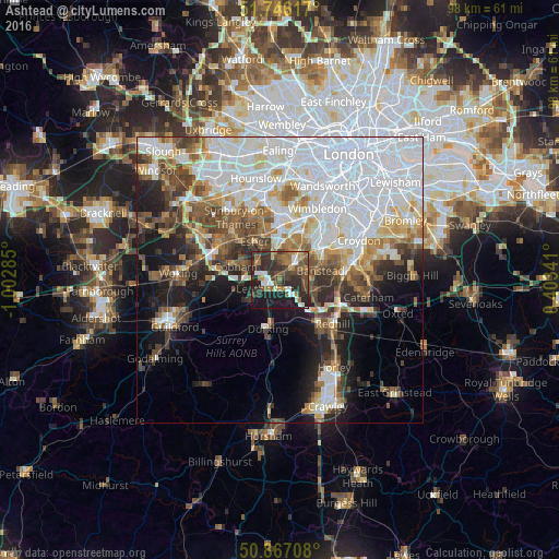
Analysis of Ashtead night lights 2016
Square area 10x10 km:
 4.2%
4.2%90-99
8.26%80-89
1.26%70-79
3.36%60-69
10.5%50-59
7.84%40-49
11.62%30-39
15.27%20-29
19.89%10-19
17.23%0-9
0.56%Square area 50x50 km:
16.86%90-99
9.22%80-89
3.69%70-79
3.86%60-69
4.49%50-59
4.97%40-49
5.38%30-39
4.58%20-29
6.04%10-19
10.08%0-9
30.84%Clear (daylight) street map image can be seen on geolist.org.
Map coordinates:
51° 44' 46.2" North, 1° 0' 10.3" West
51° 18' 31.4" North, 0° 17' 59" West
50° 52' 1.5" North, 0° 24' 12.3" East
Some cities around Ashtead sort by population:
• Banstead
6.6 km =4.1 mi,  76°
76°
• Leatherhead
2.7 km =1.7 mi,  240°
240°
• Ewell
5.7 km =3.5 mi,  37°
37°
• Epsom
3.2 km =2 mi, 40°
• Chessington
6 km =3.7 mi,  356°
356°
• Hook
6.6 km =4.1 mi, 355°
• Great Bookham
6.1 km =3.8 mi, 237°
• Tadworth
4.8 km =3 mi,  113°
113°
2656924 (p: 13,494)
Sources (retrieved 2019-11-25):
» Earth at Night: Flat Maps 2012, 2016