Featherstone night lights from space
Night Light of Featherstone (England) from space (United Kingdom) Src. Average luminocity for 10x10km area is 67.5833% and for 50x50km: 34.3998%.
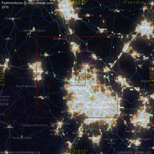
Analysis of Featherstone night lights 2016
Square area 10x10 km:
 16.67%
90-99
19.58%80-89
3.7%70-79
7.94%60-69
11.11%50-59
13.23%40-49
5.69%30-39
8.86%20-29
8.47%10-19
4.63%0-9
0.13%Square area 50x50 km:
11.65%90-99
9.3%80-89
3.15%70-79
3.12%60-69
3.03%50-59
2.39%40-49
2.91%30-39
2.2%20-29
4.37%10-19
11.53%0-9
46.36%Clear (daylight) street map image can be seen on geolist.org.
Map coordinates:
53° 4' 9.8" North, 2° 47' 46.6" West
52° 38' 41.4" North, 2° 5' 35.3" West
52° 12' 58" North, 1° 23' 24.1" West
Some cities around Featherstone sort by population:
• Wolverhampton
6.9 km =4.3 mi,  196°
196°
• Cannock
6.6 km =4.1 mi,  39°
39°
• Bloxwich
6.7 km =4.2 mi,  116°
116°
• Wednesfield
5.4 km =3.4 mi,  174°
174°
• Willenhall
7 km =4.3 mi,  161°
161°
• Great Wyrley
5.9 km =3.7 mi,  70°
70°
• Codsall
7.5 km =4.7 mi,  257°
257°
• Pelsall
8.7 km =5.4 mi,  101°
101°
6692918 (p: 14,175)
Sources (retrieved 2019-11-25):
» Earth at Night: Flat Maps 2012, 2016