Codsall night lights from space
Night Light of Codsall (England) from space (United Kingdom) Src. Average luminocity for 10x10km area is 31.9431% and for 50x50km: 30.8667%.
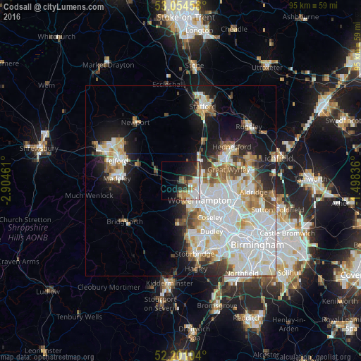
Analysis of Codsall night lights 2016
Square area 10x10 km:
 6.88%
6.88%90-99
7.14%80-89
3.04%70-79
4.89%60-69
4.23%50-59
2.25%40-49
3.04%30-39
4.76%20-29
9.52%10-19
11.51%0-9
42.72%Square area 50x50 km:
10.28%90-99
8.39%80-89
2.74%70-79
2.7%60-69
2.76%50-59
2.31%40-49
2.75%30-39
2.15%20-29
4.19%10-19
9.84%0-9
51.89%Clear (daylight) street map image can be seen on geolist.org.
Map coordinates:
53° 3' 16.5" North, 2° 54' 16.6" West
52° 37' 47.6" North, 2° 12' 5.3" West
52° 12' 3.7" North, 1° 29' 54.1" West
Some cities around Codsall sort by population:
• Wolverhampton
7.2 km =4.5 mi,  132°
132°
• Wednesfield
8.7 km =5.4 mi,  115°
115°
• Willenhall
10.8 km =6.7 mi, 117°
• Ryton
10.1 km =6.3 mi,  261°
261°
• Featherstone
7.5 km =4.7 mi,  77°
77°
• Wombourn
10.8 km =6.7 mi,  173°
173°
• Penkridge
12.1 km =7.5 mi,  28°
28°
• Shifnal
12.4 km =7.7 mi,  291°
291°
2652653 (p: 11,673)
Sources (retrieved 2019-11-25):
» Earth at Night: Flat Maps 2012, 2016