Pelsall night lights from space
Night Light of Pelsall (England) from space (United Kingdom) Src. Average luminocity for 10x10km area is 76.8452% and for 50x50km: 38.9104%.
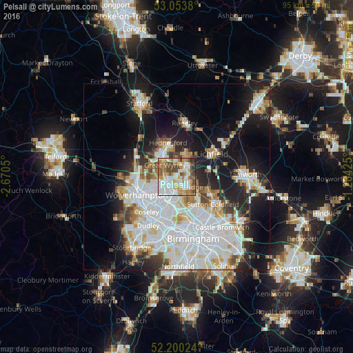
Analysis of Pelsall night lights 2016
Square area 10x10 km:
 22.35%
90-99
19.05%80-89
7.54%70-79
14.42%60-69
10.85%50-59
7.94%40-49
13.49%30-39
2.25%20-29
2.12%10-19
0%0-9
0%Square area 50x50 km:
12.71%90-99
10.56%80-89
3.4%70-79
3.42%60-69
3.45%50-59
2.68%40-49
3.26%30-39
2.8%20-29
6.49%10-19
14.6%0-9
36.63%Clear (daylight) street map image can be seen on geolist.org.
Map coordinates:
53° 3' 13.7" North, 2° 40' 13.8" West
52° 37' 44.8" North, 1° 58' 2.6" West
52° 12' 0.9" North, 1° 15' 51.3" West
Some cities around Pelsall sort by population:
• Walsall
5 km =3.1 mi,  192°
192°
• Bloxwich
2.8 km =1.7 mi,  243°
243°
• Burntwood
6.3 km =3.9 mi,  25°
25°
• Brownhills
2.3 km =1.4 mi,  78°
78°
• Great Wyrley
4.8 km =3 mi,  321°
321°
• Aldridge
4.3 km =2.7 mi,  127°
127°
• Chasetown
5.6 km =3.5 mi, 30°
• Norton Canes
4.7 km =2.9 mi,  3°
3°
2640512 (p: 10,758)
Sources (retrieved 2019-11-25):
» Earth at Night: Flat Maps 2012, 2016