Boughton night lights from space
Night Light of Boughton (England) from space (United Kingdom) Src. Average luminocity for 10x10km area is 7.3725% and for 50x50km: 17.7233%.
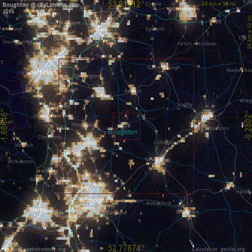
Analysis of Boughton night lights 2016
Square area 10x10 km:
 0.25%
0.25%90-99
1.14%80-89
1.01%70-79
0.63%60-69
0.76%50-59
1.26%40-49
1.14%30-39
1.52%20-29
0.88%10-19
0%0-9
91.41%Square area 50x50 km:
2.45%90-99
2.98%80-89
1.59%70-79
1.94%60-69
2.39%50-59
2.58%40-49
2.33%30-39
3.42%20-29
5.78%10-19
11.45%0-9
63.09%Clear (daylight) street map image can be seen on geolist.org.
Map coordinates:
53° 37' 8.8" North, 1° 41' 11.3" West
53° 12' 0" North, 0° 58' 60" West
52° 46' 36.3" North, 0° 16' 48.7" West
Some cities around Boughton sort by population:
• Worksop
14.7 km =9.1 mi,  320°
320°
• Retford
13.8 km =8.6 mi,  11°
11°
• Mansfield Woodhouse
14.6 km =9.1 mi,  254°
254°
• Warsop
11.3 km =7 mi,  277°
277°
• Market Warsop
11.3 km =7 mi,  272°
272°
• Rainworth
12.8 km =8 mi,  224°
224°
• Southwell
13.7 km =8.5 mi,  172°
172°
• Edwinstowe
5.4 km =3.4 mi,  263°
263°
2655117 (p: 10,120)
Sources (retrieved 2019-11-25):
» Earth at Night: Flat Maps 2012, 2016