West Byfleet night lights from space
Night Light of West Byfleet (England) from space (United Kingdom) Src. Average luminocity for 10x10km area is 45.3641% and for 50x50km: 41.4612%.
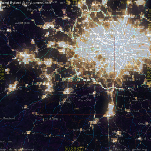
Analysis of West Byfleet night lights 2016
Square area 10x10 km:
 5.04%
5.04%90-99
4.9%80-89
3.22%70-79
7.7%60-69
8.82%50-59
8.4%40-49
12.04%30-39
13.59%20-29
16.67%10-19
19.61%0-9
0%Square area 50x50 km:
11.58%90-99
8.72%80-89
3.29%70-79
4%60-69
4.71%50-59
5.52%40-49
6.51%30-39
5.77%20-29
8.93%10-19
13.46%0-9
27.52%Clear (daylight) street map image can be seen on geolist.org.
Map coordinates:
51° 46' 29.3" North, 1° 12' 34.6" West
51° 20' 15.5" North, 0° 30' 23.4" West
50° 53' 46.6" North, 0° 11' 47.9" East
Some cities around West Byfleet sort by population:
• Woking
4.2 km =2.6 mi,  240°
240°
• Weybridge
5 km =3.1 mi,  40°
40°
• Cobham
6.7 km =4.2 mi,  97°
97°
• Addlestone
3.9 km =2.4 mi,  13°
13°
• Chertsey
5.6 km =3.5 mi,  359°
359°
• Shepperton
7.6 km =4.7 mi,  31°
31°
• Knaphill
7.8 km =4.8 mi,  255°
255°
• Send
5.6 km =3.5 mi,  194°
194°
2634478 (p: 5,054)
Sources (retrieved 2019-11-25):
» Earth at Night: Flat Maps 2012, 2016